1. Die Balkan-Halbinsel in 4 BlätternTürkei, Rumänien, Griechenland, Serbien, Montenegro, Bulgarien المؤلف: Vogel, C. (Carl), 1828-1897 (Creator) تاريخ المصدر: Date Issued: 1908 اللغة: الألمانية المكان: Place of Production: gw, Germany, GothaBalkan Peninsula المدى الزمني: 1 map : col. ; 84 x 66 cm.
2. Eastern Turkistan المؤلف: Survey of India (المنشئ) تاريخ المصدر: Date Issued: Feb. 1908 اللغة: الإنجليزية المكان: Place of Production: ii, India, [Calcutta]Asia, CentralXinjiang Uygur Zizhiqu (China)Northern Areas (Pakistan)North-West Frontier Province (Pakistan)Jammu and Kashmir (India) المدى الزمني: 1 map : col. ; 34 x 48 cm.
3. Maroc المؤلف: Flotte de Roquevaire, R. de. (المنشئ) تاريخ المصدر: Date Issued: 1908 اللغة: الفرنسية المكان: Place of Production: fr, France, ParisMoroccoAlgeriaWestern Sahara المدى الزمني: 1 map : col. ; 101 x 132 cm.
4. Die Staaten von Südost=EuropaRumänien, Serbien, Montenegro, Bulgarien, Kreta, Europ. Türkei, Griechenland المؤلف: Peucker, Karl, 1859-1940 (المنشئ) تاريخ المصدر: Date Issued: 1903 اللغة: الألمانية المكان: Place of Production: au, Austria, WienBalkan PeninsulaTurkey المدى الزمني: 1 map : col. ; 51 x 37 cm.
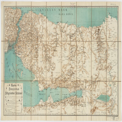
5. Karte des Bosporus und der Bithynischen Halbinsel المؤلف: Fitzner, Rudolph, 1864- (المنشئ) تاريخ المصدر: Date Issued: [1900?] اللغة: الألمانية المكان: Place of Production: gw, Germany, Rostockİstanbul İli (Turkey)Kocaeli İli (Turkey)Sakarya İli (Turkey)Bosporus (Turkey) المدى الزمني: 1 map : col. ; 47 x 87 cm.
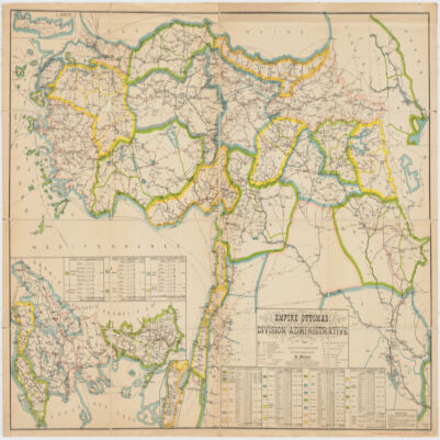
6. Empire Ottomandivision administrative المؤلف: Huber, R. (المنشئ) تاريخ المصدر: Date Issued: 1899 اللغة: الفرنسية المكان: Place of Production: fr, France, [S.l.]Turkey المدى الزمني: 1 map : col. ; 86 x 130 cm.
7. Carte de la Tunisie المؤلف: Institut géographique national (France) (Creator) تاريخ المصدر: Date Issued: 1895 اللغة: الفرنسيةالعربيةاللاتينية المكان: Place of Production: fr, France, ParisTunisia المدى الزمني: 1 map on 2 sheets : col. ; 110 x 65 cm., sheet 58 x 71 cm.
8. Carte de la Tunisie المؤلف: Institut géographique national (France) (Creator) تاريخ المصدر: Date Issued: 1895 اللغة: الفرنسيةالعربيةاللاتينية المكان: Place of Production: fr, France, ParisTunisia المدى الزمني: 1 map on 2 sheets : col. ; 110 x 65 cm., sheet 58 x 71 cm.
9. Carte de la Tunisie المؤلف: Institut géographique national (France) (Creator) تاريخ المصدر: Date Issued: 1895 اللغة: الفرنسيةالعربيةاللاتينية المكان: Place of Production: fr, France, ParisTunisia المدى الزمني: 1 map on 2 sheets : col. ; 110 x 65 cm., sheet 58 x 71 cm.
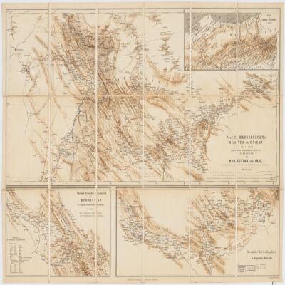
10. Prof. C. Haussknecht's Routen im Orient 1865-1869III. Kurdistan und Irak المؤلف: Kiepert, Heinrich, 1818-1899 (المنشئ) تاريخ المصدر: Date Issued: 1882 اللغة: الألمانيةالتركيةالفارسية المكان: Place of Production: gw, Germany, BerlinKurdistanMiddle East المدى الزمني: 1 map : col. ; 32 x 71 cm.
11. Palestine ancienne & moderne d'après les sources les plus authentiques المؤلف: Andriveau-Goujon, E. (Eugène), 1832-1897 (المنشئ) تاريخ المصدر: Date Issued: 1876 اللغة: الفرنسيةاللاتينيةالعربيةالعبرية المكان: Place of Production: fr, France, ParisPalestineLebanon المدى الزمني: 1 map : col. ; 62 x 46 cm.
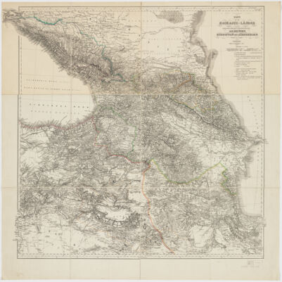
12. Karte der Kaukasus-Länder und der angränzenden Türkischen und Persischen Provinzen Armenien, Kurdistan, und Azerbeidjan المؤلف: Kiepert, Heinrich, 1818-1899 (المنشئ) تاريخ المصدر: Date Issued: 1854 اللغة: الألمانية المكان: Place of Production: gw, Germany, BerlinCaucasus المدى الزمني: 1 map : hand col., dissected and mounted on linen ; 69 x 75 cm.