1. A generall mapp of the Coast of Barbarie, where in are the Kingdoms, and Estates of Morocco, Fez, Algiers, Tunis and Tripolialso the Kingdoms, Estates and Deserts of Barca, Egipt, Libya, Biledulgerid, Segelmesse and Darha: with the circumjacent counteries المؤلف: Sanson, Nicolas, 1600-1667 (المنشئ) تاريخ المصدر: Date Issued: 1667?] اللغة: الإنجليزيةالفرنسية المكان: Place of Production: enk, England, [LondonMoroccoTunisiaAlgeriaMauritania المدى الزمني: 1 map on 2 sheets ; 28 x 106 cm, sheets 35 x 57 cm and 35 x 59 cm.
2. A generall mapp of the Coast of Barbarie, where in are the Kingdoms, and Estates of Morocco, Fez, Algiers, Tunis and Tripolialso the Kingdoms, Estates and Deserts of Barca, Egipt, Libya, Biledulgerid, Segelmesse and Darha: with the circumjacent counteries المؤلف: Sanson, Nicolas, 1600-1667 (المنشئ) تاريخ المصدر: Date Issued: 1667?] اللغة: الإنجليزيةالفرنسية المكان: Place of Production: enk, England, [LondonMoroccoTunisiaAlgeriaMauritania المدى الزمني: 1 map on 2 sheets ; 28 x 106 cm, sheets 35 x 57 cm and 35 x 59 cm.
3. Indian Ocean Region, ca. 1690 (Raster Image) تاريخ المصدر: 201110 المكان: AfghanistanAlgeriaAngolaArmeniaAustraliaAzerbaijanBahrainBangladeshBhutanBotswanaBritish Indian Ocean TerritoryBruneiBurmaBurundiCambodiaCameroonCentral Africian RepublicChadChinaChristmas IslandCocos (Keeling) IslandsComorosCongo, Democratic Republic of theCongo, Republic of theDjiboutiEgyptEritreaEthiopiaGabonGlorioso IslandsGuamIndiaIndonesiaIranIraqIsraelJapanJordanJuan de Nova IslandKazakhstanKenyaKuwaitKyrgyzstanLaosLesothoLibyaMadagascarMalawiMalaysiaMaldivesMauritiusMayotteMozambiqueNamibiaNepalNigerNigeriaNorth KoreaNorthern Mariana IslandsOmanPakistanPalauPapua New GuineaPhilippinesQatarReunionRwandaSaudi ArabiaSeychellesSingaporeSomaliaSouth AfricaSouth KoreaSri LankaSudanSwazilandSyriaTajikistanTanzaniaThailandTimor-LesteTurkeyTurkmenistanUgandaUnited Arab EmiratesUzbekistanVietnamYemenZambiaZimbabweIndian OceanAsiaSouth AsiaSoutheast AsiaAfrica, East177.31452253.283629-65.180727-13.682351
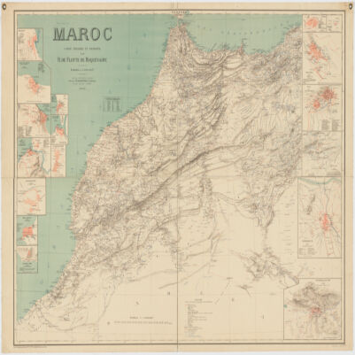
4. Maroc المؤلف: Flotte de Roquevaire, R. de. (المنشئ) تاريخ المصدر: Date Issued: 1908 اللغة: الفرنسية المكان: Place of Production: fr, France, ParisMoroccoAlgeriaWestern Sahara المدى الزمني: 1 map : col. ; 101 x 132 cm.
5. Ottoman Empire, ca. 1790 (Raster Image) تاريخ المصدر: 201001 المكان: AlbaniaAlgeriaArmeniaAustriaAzerbaijanBahrainBosnia & HerzegovinaBulgariaCroatiaCyprusEgyptEritreaFranceGaza StripGeorgiaGreeceHungaryIranIraqIsraelItalyJordanKazakhstanKuwaitLebanonLibyaMacedoniaMaltaMoldovaMontenegroOmanPolandQatarRomaniaRussiaSan MarinoSaudi ArabiaSerbiaSlovakiaSloveniaSomaliaSudanSyriaTunisiaTurkeyTurkmenistanUkraineUnited Arab EmiratesUzbekistanVatican CityWest BankYemen89.99419957.5464463.534051-14.597445
6. Red Sea Region, North Africa, ca. 1730 (Raster Image) تاريخ المصدر: 201312 المكان: AfricaAfrica, NorthRed SeaArabian PeninsulaMediterranean SeaAlgeriaAzerbaijanBahrainCameroonCentral African RepublicChadCongoCongo Democratic Republic of theCyprusDijiboutiEgyptEritreaEthiopiaGaza StripGreeceIranIraqIsraelItalyJordanKenyaKuwaitLebanonLibyaMaltaNigerNigeriaOmanQatarSaudi ArabiaSomaliaSudanSyriaTunisiaTurkeyUgandaUnited Arab EmiratesWest BankYemen84.36247844.728074-5.683373-5.414094
7. al- Bustān fī dhikr al-awliyāʼ wa-al-ʻulamāʼ bi-Tilimsān المؤلف: Ibn Maryam, Muḥammad ibn Muḥammad, active 17th century (المنشئ) تاريخ المصدر: Date Issued: 1908Date Issued: 1908. اللغة: العربية المكان: مكان الإنتاج: الجزائرPlace of Production: ae, Algeria, al-JazāʼirAlgeriaTlemcen (Algeria) المدى الزمني: 315, 65 p. ; 25 cm.