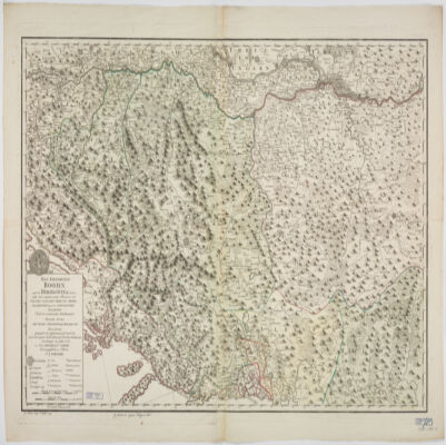
31. Das Kœnigreich Bosnien, und die Herzegovina (Rama) samt den angrœnzenden Provinzen von Croatien, Sclavonien, Temesvar, Servien, Albanien, Ragusa, und den Venetianischen Dalmatien Creator: Schimek, Maximilian. (المنشئ) Date: Date Issued: 1788 Language: German Geographic region: Place of Production: au, Austria, WienBalkan Peninsula Extent: 1 map : hand col. ; 65 x 103 cm.
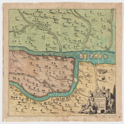
32. Delineatio regionis Bassora cum pagis fluminibus et insulis, quæ christiani sancti Ioannis incolunt Creator: Dapper, Olfert, 1635 or 1636-1689 (المنشئ) Date: Date Issued: 1680?] Language: Latin Geographic region: Place of Production: ne, Netherlands, [AmsterdamIraqBaṣrah Region (Iraq) Extent: 1 map : hand col. ; 29 x 36 cm.
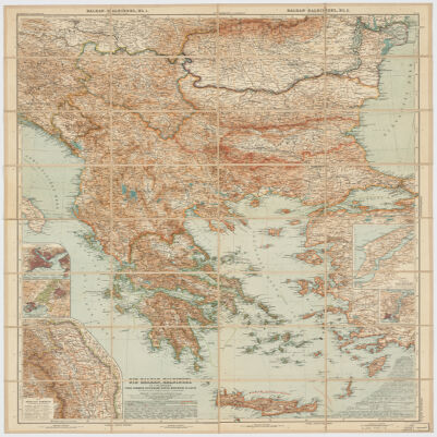
33. Die Balkan-Halbinsel in 4 BlätternTürkei, Rumänien, Griechenland, Serbien, Montenegro, Bulgarien Creator: Vogel, C. (Carl), 1828-1897 (Creator) Date: Date Issued: 1908 Language: German Geographic region: Place of Production: gw, Germany, GothaBalkan Peninsula Extent: 1 map : col. ; 84 x 66 cm.
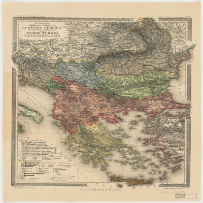
34. Die Staaten von Südost=EuropaRumänien, Serbien, Montenegro, Bulgarien, Kreta, Europ. Türkei, Griechenland Creator: Peucker, Karl, 1859-1940 (المنشئ) Date: Date Issued: 1903 Language: German Geographic region: Place of Production: au, Austria, WienBalkan PeninsulaTurkey Extent: 1 map : col. ; 51 x 37 cm.
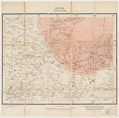
35. Eastern Turkistan Creator: Survey of India (المنشئ) Date: Date Issued: Feb. 1908 Language: English Geographic region: Place of Production: ii, India, [Calcutta]Asia, CentralXinjiang Uygur Zizhiqu (China)Northern Areas (Pakistan)North-West Frontier Province (Pakistan)Jammu and Kashmir (India) Extent: 1 map : col. ; 34 x 48 cm.
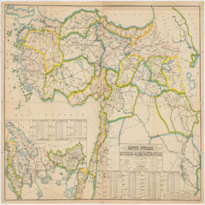
36. Empire Ottomandivision administrative Creator: Huber, R. (المنشئ) Date: Date Issued: 1899 Language: French Geographic region: Place of Production: fr, France, [S.l.]Turkey Extent: 1 map : col. ; 86 x 130 cm.
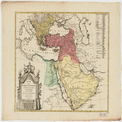
37. Empire de la Porte ottomane en Europe, en Asie et en Afrique avec les pays qui lui sont tributaires Creator: Lotter Brothers (Firm) (Creator) Date: Date Issued: [1790?] Language: French Geographic region: Place of Production: gw, Germany, AugsburgMiddle EastTurkeyEurope, SouthernAfrica, North Extent: 1 map : hand col. ; 47 x 55 cm.
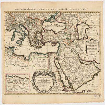
38. Estats de l'Empire du grand Seigneur des Turcs en Europe, en Asie, et en Afriquedivisé en tous ses Beglerbeglicz ou Gouvernements; où sont aussi remarqués les Estats qui luy sont Tributaires Creator: Jaillot, Alexis Hubert, 1632?-1712 (المنشئ) Date: Date Issued: 1696 Language: Latin Geographic region: Place of Production: fr, France, ParisTurkeyMiddle EastAfrica, NorthEurope, SouthernNorth AfricaSouthern Europe Time period: Ottoman Empire, 1288-1918 Extent: 1 map : hand colored ; 44 x 60 cm
39. Europe & Mediterranean Sea Region, 1705 (Image 2 of 2) (Raster Image) Date: 201109 Geographic region: Mediterranean SeaBlack SeaAlbaniaArmeniaAzerbaijanBosnia and HerzegovinaBulgariaCroatiaCyprusEgyptGaza StripGeorgiaGreeceHungaryIsraelItalyJordanKazakhstanLebanonLibyaMacedoniaMoldovaMontenegroPolandRomaniaRussiaSaudi ArabiaSerbiaSlovakiaSyriaTurkeyUkraineWest BankEuropeAfrica, NorthMiddle East59.63941753.88769019.1023876.174040 Extent: 2 images
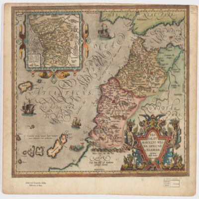
40. Fessae, et Marocchi Regna Africae celeberr Creator: Ortelius, Abraham, 1527-1598 (المنشئ) Date: Date Issued: 1595 Language: Latin Geographic region: Place of Production: be, Belgium, [Antwerp]MoroccoGibraltar, Strait ofCanary Islands Extent: 1 map : hand col. ; 37 x 48 cm.