1. A generall mapp of the Coast of Barbarie, where in are the Kingdoms, and Estates of Morocco, Fez, Algiers, Tunis and Tripolialso the Kingdoms, Estates and Deserts of Barca, Egipt, Libya, Biledulgerid, Segelmesse and Darha: with the circumjacent counteries Creator: Sanson, Nicolas, 1600-1667 (المنشئ) Date: Date Issued: 1667?] Language: EnglishFrench Geographic region: Place of Production: enk, England, [LondonMoroccoTunisiaAlgeriaMauritania Extent: 1 map on 2 sheets ; 28 x 106 cm, sheets 35 x 57 cm and 35 x 59 cm.
2. A generall mapp of the Coast of Barbarie, where in are the Kingdoms, and Estates of Morocco, Fez, Algiers, Tunis and Tripolialso the Kingdoms, Estates and Deserts of Barca, Egipt, Libya, Biledulgerid, Segelmesse and Darha: with the circumjacent counteries Creator: Sanson, Nicolas, 1600-1667 (المنشئ) Date: Date Issued: 1667?] Language: EnglishFrench Geographic region: Place of Production: enk, England, [LondonMoroccoTunisiaAlgeriaMauritania Extent: 1 map on 2 sheets ; 28 x 106 cm, sheets 35 x 57 cm and 35 x 59 cm.
3. Africa, 1611 or 1612 (Raster Image) Date: 201204 Geographic region: AfricaMiddle EastEurope87.69118444.063898-44.943919-57.577607
4. Africa, 1700 (Raster Image) Date: 201202 Geographic region: Africa136.26490853.059878-47.801774-83.671687
5. Africa, 1730-1740 (Raster Image) Date: 201202 Geographic region: Africa87.87828149.440254-47.173313-56.184308
6. Africa, 1785 (Image 2 of 2) (Raster Image) Date: 201202 Geographic region: Africa129.30122453.016479-53.6349089.414992
7. Africa, ca. 1680-1689 (Raster Image) Date: 201202 Geographic region: Africa116.36916252.713700-49.459512-86.118662
8. Africa, ca. 1725 (Raster Image) Date: 201204 Geographic region: AfricaMiddle EastEurope168.83259062.467856-63.513477-123.381192
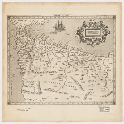
9. Africae I Tab Creator: Mercator, Gerhard, 1512-1594 (المنشئ) Date: Date Issued: 1619?] Language: Latin Geographic region: Place of Production: xx, No place, unknown, or undetermined, [S.lAfrica, North Extent: 1 map ; 31 x 45 cm.
10. Akhbār al-uwal fī-man taṣarrafa fī Miṣr min arbāb al-duwal Creator: Isḥāqī, Muḥammad ibn ʻAbd al-Muʻṭī, -1649 or 1650 (المنشئ) Date: Date Created: 1733 Language: Arabic Geographic region: Place of Production: xx, No place, unknown, or undeterminedEgypt Time period: 640-1882 Extent: 1 v. (325 leaves) ; 21 cm.
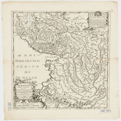
11. Albania Propria ouero Superiore detta anche Macedonia Occidentale Creator: Cantelli da Vignola, Giacomo, 1643-1719 (المنشئ) Date: Date Issued: 1689 Language: Italian Geographic region: Place of Production: it, Italy, RomaAlbania Extent: 1 map : 52 x 42 cm.
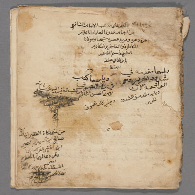
12. Alfāẓ al-kufr ʻalá madhhab al-Imām al-Shāfīʻī Creator: Ibn al-Khānī, Qāsim, 1233-1277 (المنشئ) Date: Date Created: 1680 Language: Arabic Geographic region: Place of Production: xx, No place, unknown, or undetermined Extent: 14 leaves ; 21 cm.