1. A generall mapp of the Coast of Barbarie, where in are the Kingdoms, and Estates of Morocco, Fez, Algiers, Tunis and Tripolialso the Kingdoms, Estates and Deserts of Barca, Egipt, Libya, Biledulgerid, Segelmesse and Darha: with the circumjacent counteries Creator: Sanson, Nicolas, 1600-1667 (المنشئ) Date: Date Issued: 1667?] Language: EnglishFrench Geographic region: Place of Production: enk, England, [LondonMoroccoTunisiaAlgeriaMauritania Extent: 1 map on 2 sheets ; 28 x 106 cm, sheets 35 x 57 cm and 35 x 59 cm.
2. A generall mapp of the Coast of Barbarie, where in are the Kingdoms, and Estates of Morocco, Fez, Algiers, Tunis and Tripolialso the Kingdoms, Estates and Deserts of Barca, Egipt, Libya, Biledulgerid, Segelmesse and Darha: with the circumjacent counteries Creator: Sanson, Nicolas, 1600-1667 (المنشئ) Date: Date Issued: 1667?] Language: EnglishFrench Geographic region: Place of Production: enk, England, [LondonMoroccoTunisiaAlgeriaMauritania Extent: 1 map on 2 sheets ; 28 x 106 cm, sheets 35 x 57 cm and 35 x 59 cm.
3. Carte de la Tunisie Creator: Institut géographique national (France) (Creator) Date: Date Issued: 1895 Language: FrenchArabicLatin Geographic region: Place of Production: fr, France, ParisTunisia Extent: 1 map on 2 sheets : col. ; 110 x 65 cm., sheet 58 x 71 cm.
4. Carte de la Tunisie Creator: Institut géographique national (France) (Creator) Date: Date Issued: 1895 Language: FrenchArabicLatin Geographic region: Place of Production: fr, France, ParisTunisia Extent: 1 map on 2 sheets : col. ; 110 x 65 cm., sheet 58 x 71 cm.
5. Carte de la Tunisie Creator: Institut géographique national (France) (Creator) Date: Date Issued: 1895 Language: FrenchArabicLatin Geographic region: Place of Production: fr, France, ParisTunisia Extent: 1 map on 2 sheets : col. ; 110 x 65 cm., sheet 58 x 71 cm.
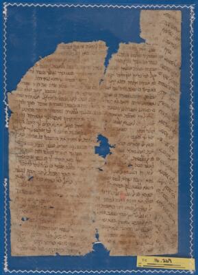
6. Letter T-S 16.269 Date: 6th-19th century Language: Judeo-ArabicHebrew Geographic region: Tunisia Medium: Paper Extent: Leaf: (height: 29 cm, width: 20 cm)
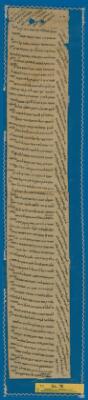
7. Letter T-S 24.78 Creator: Maḵlūf b. Mūsā al-Nafūsī Date: 1131 CE Language: Judeo-ArabicHebrewArabic Geographic region: Tunisia Medium: Paper Extent: Leaf: (height: 52.7 cm, width: 8.9 cm)
9. Ottoman Empire, ca. 1790 (Raster Image) Date: 201001 Geographic region: AlbaniaAlgeriaArmeniaAustriaAzerbaijanBahrainBosnia & HerzegovinaBulgariaCroatiaCyprusEgyptEritreaFranceGaza StripGeorgiaGreeceHungaryIranIraqIsraelItalyJordanKazakhstanKuwaitLebanonLibyaMacedoniaMaltaMoldovaMontenegroOmanPolandQatarRomaniaRussiaSan MarinoSaudi ArabiaSerbiaSlovakiaSloveniaSomaliaSudanSyriaTunisiaTurkeyTurkmenistanUkraineUnited Arab EmiratesUzbekistanVatican CityWest BankYemen89.99419957.5464463.534051-14.597445
10. Red Sea Region, North Africa, ca. 1730 (Raster Image) Date: 201312 Geographic region: AfricaAfrica, NorthRed SeaArabian PeninsulaMediterranean SeaAlgeriaAzerbaijanBahrainCameroonCentral African RepublicChadCongoCongo Democratic Republic of theCyprusDijiboutiEgyptEritreaEthiopiaGaza StripGreeceIranIraqIsraelItalyJordanKenyaKuwaitLebanonLibyaMaltaNigerNigeriaOmanQatarSaudi ArabiaSomaliaSudanSyriaTunisiaTurkeyUgandaUnited Arab EmiratesWest BankYemen84.36247844.728074-5.683373-5.414094
11. Shawabti Geographic region: TunisiaCarthage Time period: Twenty-Sixth DynastyTwenty-Seventh DynastyTwenty-Eighth dynastyTwenty-Nineth DynastyThirtieth Dynasty Medium: Faience
12. Tārīkh al-dawlatayn al-Muwaḥḥidīyah wa-al-Ḥafṣīyah Creator: Zarkashī, Muḥammad ibn Ibrāhīm, -approximately 1526 (المنشئ) Date: Date Issued: 1289 [1872 or 1873] Language: Arabic Geographic region: Place of Production: ti, Tunisia, [Tunis]Africa, NorthTunis (Tunisia)Tunisia Time period: 647-1516 Extent: 155 p. ; 22 cm.