49. Les Peintres du Liban00 Creator: Douaihy, Saliba Contributor: Saliba DouaihyVictor HakimOmar OnsiBibi ZogbeGeorges CyrCharles Corn Date: 1949 Language: French
50. Les Peintres du Liban05 Creator: Douaihy, Saliba Contributor: Saliba DouaihyVictor HakimOmar OnsiBibi ZogbeGeorges CyrCharles Corn Date: 1949 Language: French
51. Les Peintres du Liban03 Creator: Douaihy, Saliba Contributor: Saliba DouaihyVictor HakimOmar OnsiBibi ZogbeGeorges CyrCharles Corn Date: 1949 Language: French
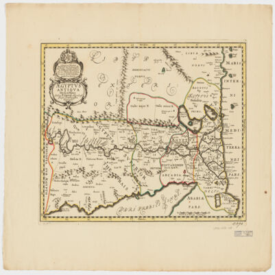
52. Ægyptus antiqua divisa in Nomos Creator: Duval, P. (Pierre), 1619-1682 (Creator) Date: Date Issued: 1652?] Language: LatinFrench Geographic region: Place of Production: ne, Netherlands, [AmsterdamEgypt Extent: 1 map : hand col. ; 35 x 50 cm.
53. Plan des Necropoles Thebaines Creator: E Baraize; Egypt. Maṣlaḥat al-Āthār Date: 1912 Language: French Geographic region: Thebes; Qinā; Egypt
54. Maps from "Tārīkh al-barīd fī Miṣr" Creator: Egypt. Maṣlaḥat al-Barīd Date: 1934 Language: ArabicFrench Geographic region: Egypt
56. "Etudes géographiques et géologiques de l'Egyptede la Péninsule de l'Arabie Petrée et de la Palestine " Creator: Figari Bey, Antonio. Date: 1864 Language: French
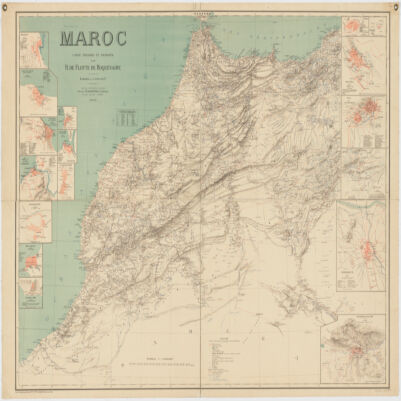
57. Maroc Creator: Flotte de Roquevaire, R. de. (المنشئ) Date: Date Issued: 1908 Language: French Geographic region: Place of Production: fr, France, ParisMoroccoAlgeriaWestern Sahara Extent: 1 map : col. ; 101 x 132 cm.
58. Plan général de la Ville du Caire Creator: Grand, Pierre Bey Date: 1874 Language: French Geographic region: Cairo; Egypt
59. "Plan d'Alexandrie ancienne : dressé d'après les travaux de Néroutsoa Bey et le Prof. E.Breccia" Creator: Hausermann, A. Date: publication date not identified Language: French Geographic region: Relief shown by contour lines, gradient tints, spot heights, and land forms.
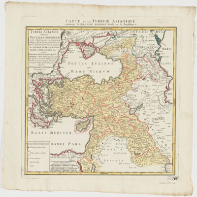
60. Turcia Asiaticaexhibens Natoliam modernam, in suos beglirbegatus divisam, itemque reliquos beglirbegatus, sive gubernationes et Prœfecturas generales, in regionibus Georgiæ, Armeniæ, Mespotamiæ, Syriæ et Arabiæ sitos, una cum Mari Nigro, Mari Azowiensi, Mari di Marmora, et Mari Ægeo, atque adiacentibus Insulis : C. P. S. C. M. = Carte de la Turquie asiatique contenant la Natolie moderne divisée en les beglerbeys & Creator: Homann Erben (Firm) (Creator) Date: Date Issued: 1771 Language: LatinFrench Geographic region: Place of Production: gw, Germany, NorimbergæMiddle EastTurkey Extent: 1 map : hand col. ; 44 x 51 cm.