1. ‘The Entrance to the Gulf of Persia; and Coast of Arabia from Ras Goberindee to Muscat. Surveyed by Com.r G.B. Brucks, and Lt. S.B. Haines, H.C. Marine, 1828. Engraved by Richard Bateman’ Contributor: George Edward Brucks (surveyor)Stafford Bettesworth Haines (surveyor)Richard Bateman (artist)James Horsburgh (publisher) Date: 1831/1831 Language: English Geographic region: Strait of Hormuz Extent: 1 map
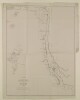
2. ‘SKETCH MAP OF THE ROUTE FROM BUNDER ABBAS TO CAPE JASK. 1864. Protracted by Mr Dawes, late Indian Navy to accompany Coll. Pelly’s Dispatch No. 73 of 1864’ Date: 1864/1864 Language: English Geographic region: Strait of Hormuz Extent: 1 map
3. 'Sketch map of the route from Bunder Abbas to Cape Jask. 1864' Date: 1864/1864 Language: English Geographic region: Strait of Hormuz Extent: 1 map
4. ‘Entrance to the Gulf, and Musandim Island’ Date: 1906/1906 Language: English Geographic region: Strait of HormuzMussandim Extent: 1 map