1. 5 grañth ne 100 ginān bhāj 2 jo Creator: Pīr Imām Shāh, 1430-1512 (المنشئ) Date: Date Issued: 1903 Language: Indic languages Geographic region: Place of Production: ii, India, Bombay Extent: 243 p. : ill. ; 23 cm.
2. 100 ginānjī ćopaḍī ćogaḍīevārī Creator: Pīr Ṣadr ad-Dīn, active 14th century (المنشئ) Date: Date Issued: 1903 Language: Indic languages Geographic region: Place of Production: ii, India, Bombay Extent: 133 p. : ill. ; 24 cm.
3. 100 ginānjī:ćopaḍī:ćogaḍīe:vārī Creator: Pīr Ṣadr ad-Dīn, active 14th century (المنشئ) Date: Date Issued: 1890 Language: Indic languages Geographic region: Place of Production: ii, India, Bombay Extent: 184 p. ; 24 cm.
4. 100:ginānjī:ćopaḍī:cālû:ginān:āgal:na:ćhapāela:bhāg:trījo Creator: Pīr Imām Shāh, 1430-1512 (المنشئ) Date: Date Issued: 1903 Language: Indic languages Geographic region: Place of Production: ii, India, Bombay Extent: 151 p. ; ill. ; 23 cm.
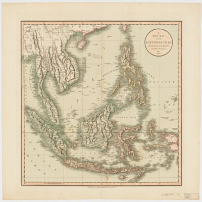
5. A new map of the East India Islesfrom the latest authorities Creator: Cary, John, approximately 1754-1835 (المنشئ) Date: Date Issued: Dec. 21, 1801 Language: English Geographic region: Place of Production: enk, England, LondonSoutheast AsiaEast IndiesIndonesiaMalay PeninsulaIndochinaPhilippines Extent: 1 map : hand col. ; 44 x 50 cm.
6. Abḥāth al-mulakhkhaṣah fī ḥukm kayy al-ḥimmaṣah Creator: Nābulusī, ʻAbd al-Ghanī ibn Ismāʻīl, 1641-1731 (المنشئ) Date: Date Created: 1813 Language: Arabic Geographic region: Place of Production: sy, Syria Extent: 3 leaves ; 21 cm.
7. Africa with expedition routes, 1884 (Raster Image) Date: 200906 Geographic region: Africa103.12254157.594282-50.263329-73.867930
8. Africa, 1800 (Raster Image) Date: 200905 Geographic region: Africa86.28407445.041388-45.849318-71.450052
9. Africa, 1805 (Raster Image) Date: 201202 Geographic region: Africa113.18103950.051365-43.455261-73.270698
10. Africa, 1815 (Raster Image) Date: 201202 Geographic region: Africa75.38448942.475973-39.724793-39.673843
11. Africa, 1834 (Raster Image) Date: 201202 Geographic region: Africa82.86500951.679764-51.621508-45.965406
12. Africa, 1890 (Raster Image) Date: 200905 Geographic region: Africa155.72943271.330211-45.438705-126.032625