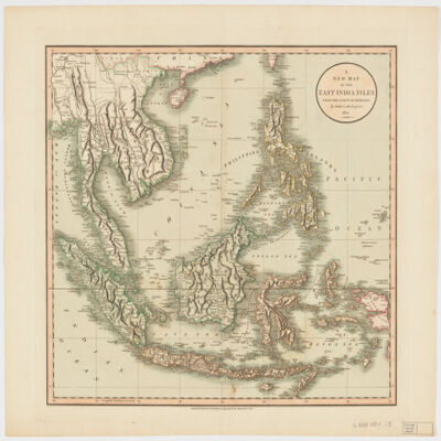
1. A new map of the East India Islesfrom the latest authorities Creator: Cary, John, approximately 1754-1835 (المنشئ) Date: Date Issued: Dec. 21, 1801 Language: English Geographic region: Place of Production: enk, England, LondonSoutheast AsiaEast IndiesIndonesiaMalay PeninsulaIndochinaPhilippines Extent: 1 map : hand col. ; 44 x 50 cm.
2. Indian Ocean Region, ca. 1690 (Raster Image) Date: 201110 Geographic region: AfghanistanAlgeriaAngolaArmeniaAustraliaAzerbaijanBahrainBangladeshBhutanBotswanaBritish Indian Ocean TerritoryBruneiBurmaBurundiCambodiaCameroonCentral Africian RepublicChadChinaChristmas IslandCocos (Keeling) IslandsComorosCongo, Democratic Republic of theCongo, Republic of theDjiboutiEgyptEritreaEthiopiaGabonGlorioso IslandsGuamIndiaIndonesiaIranIraqIsraelJapanJordanJuan de Nova IslandKazakhstanKenyaKuwaitKyrgyzstanLaosLesothoLibyaMadagascarMalawiMalaysiaMaldivesMauritiusMayotteMozambiqueNamibiaNepalNigerNigeriaNorth KoreaNorthern Mariana IslandsOmanPakistanPalauPapua New GuineaPhilippinesQatarReunionRwandaSaudi ArabiaSeychellesSingaporeSomaliaSouth AfricaSouth KoreaSri LankaSudanSwazilandSyriaTajikistanTanzaniaThailandTimor-LesteTurkeyTurkmenistanUgandaUnited Arab EmiratesUzbekistanVietnamYemenZambiaZimbabweIndian OceanAsiaSouth AsiaSoutheast AsiaAfrica, East177.31452253.283629-65.180727-13.682351
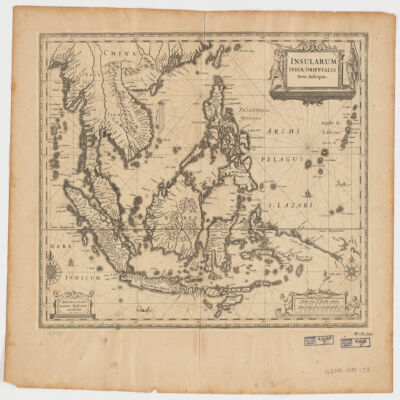
3. Insularum Indiae Orientalisnova descriptio Creator: Jansson, Jan, 1588-1664 (المنشئ) Date: Date Issued: [1650?] Language: Latin Geographic region: Place of Production: ne, Netherlands, AmstelodamiSoutheast AsiaEast Indies Extent: 1 map ; 37 x 48 cm.
4. Oceania, 1836 (Raster Image) Date: 200911 Geographic region: OceaniaPacific OceanAustraliaSoutheast Asia180.00000046.786127-64.376995-180.000000