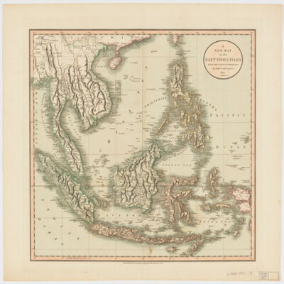
1. A new map of the East India Islesfrom the latest authorities Creator: Cary, John, approximately 1754-1835 (المنشئ) Date: Date Issued: Dec. 21, 1801 Language: English Geographic region: Place of Production: enk, England, LondonSoutheast AsiaEast IndiesIndonesiaMalay PeninsulaIndochinaPhilippines Extent: 1 map : hand col. ; 44 x 50 cm.
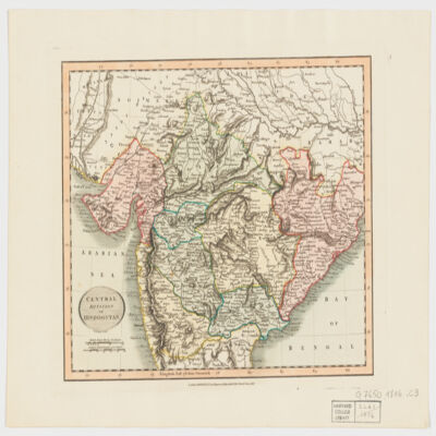
2. Central division of Hindoostan Creator: Cary, John, approximately 1754-1835 (المنشئ) Date: Date Issued: June 1, 1816 Language: English Geographic region: Place of Production: enk, England, LondonIndia Extent: 1 map : hand col. ; 22 x 27 cm.
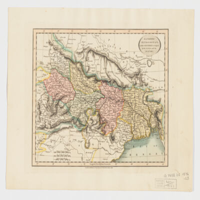
3. Gangetic Hindoostan or the countries occupied by the Ganges and the branches Creator: Cary, John, approximately 1754-1835 (المنشئ) Date: Date Issued: June 1, 1816 Language: English Geographic region: Place of Production: enk, England, LondonIndia, NortheasternBangladeshNepal Extent: 1 map : hand col. ; 22 x 27 cm.
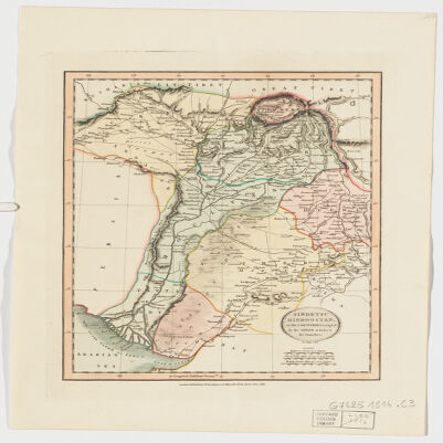
4. Sindetic Hindoostan or the countries occupied by the Sinde or Indus and its branches Creator: Cary, John, approximately 1754-1835 (المنشئ) Date: Date Issued: June 1, 1816 Language: English Geographic region: Place of Production: enk, England, LondonSouth Asia Extent: 1 map : hand col. ; 27 x 22 cm.