1. "Etudes géographiques et géologiques de l'Egyptede la Péninsule de l'Arabie Petrée et de la Palestine " Creator: Figari Bey, Antonio. Date: 1864 Language: French
2. 'I SKETCH MAP OF MESOPOTAMIA AND THE TURCO-PERSIAN FRONTIER' Date: 1916/1916 Language: EnglishFrench Extent: 1 map
3. "Plan d'Alexandrie ancienne : dressé d'après les travaux de Néroutsoa Bey et le Prof. E.Breccia" Creator: Hausermann, A. Date: publication date not identified Language: French Geographic region: Relief shown by contour lines, gradient tints, spot heights, and land forms.
4. "Societe Royale D'AgriculturePlan General de la XVIe Exposition Agricole et Industrielle" Creator: "Societe Royale d'Agriculture" Date: 1949 Language: French Geographic region: Cairo; Egypt
5. "Voyages d'Ali Bey El Abbassi en Afrique et en Asie pendant les années 1803180418051806 et 1807." Creator: Ali Bey, 1766-1818. Date: 1814 Language: French Geographic region: North Africa; Middle East
10. ‘Carte concernant l’exploitation des pètroles du Nord, Est et de l’Est confordément au projet présenté à la Chambre’ Date: 1937/1937 Language: FrenchPersian Extent: 1 map
11. 'GULF OF TAJURA. JIBUTI BAY' Date: 1895/1895 Language: EnglishFrench Geographic region: Gulf of Tajura Extent: 1 map
12. 'Maps from "Histoire de l\'Égypte sous le gouvernement de Mohammed-AlyouRécit des événemens politiques et militaires qui ont eu lieu depuis le départ des Français jusqu\'en 1823"' Date: 1823 Language: French
13. A generall mapp of the Coast of Barbarie, where in are the Kingdoms, and Estates of Morocco, Fez, Algiers, Tunis and Tripolialso the Kingdoms, Estates and Deserts of Barca, Egipt, Libya, Biledulgerid, Segelmesse and Darha: with the circumjacent counteries Creator: Sanson, Nicolas, 1600-1667 (المنشئ) Date: Date Issued: 1667?] Language: EnglishFrench Geographic region: Place of Production: enk, England, [LondonMoroccoTunisiaAlgeriaMauritania Extent: 1 map on 2 sheets ; 28 x 106 cm, sheets 35 x 57 cm and 35 x 59 cm.
14. A generall mapp of the Coast of Barbarie, where in are the Kingdoms, and Estates of Morocco, Fez, Algiers, Tunis and Tripolialso the Kingdoms, Estates and Deserts of Barca, Egipt, Libya, Biledulgerid, Segelmesse and Darha: with the circumjacent counteries Creator: Sanson, Nicolas, 1600-1667 (المنشئ) Date: Date Issued: 1667?] Language: EnglishFrench Geographic region: Place of Production: enk, England, [LondonMoroccoTunisiaAlgeriaMauritania Extent: 1 map on 2 sheets ; 28 x 106 cm, sheets 35 x 57 cm and 35 x 59 cm.
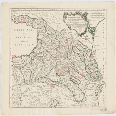
16. Carte de la Géorgie et des pays situés entre la mer Noire et la mer Caspiennedessinée en 1738 d'après les Cartes, Mémoires, Mesures et Observations des gens du Pays Creator: Santini, P. (المنشئ) Date: Date Issued: 1775 Language: FrenchGeorgian Geographic region: Place of Production: it, Italy, VeniceGeorgia (Republic)Armenia Extent: 1 map : hand col. ; 46 x 64 cm.
17. Carte de la Tunisie Creator: Institut géographique national (France) (Creator) Date: Date Issued: 1895 Language: FrenchArabicLatin Geographic region: Place of Production: fr, France, ParisTunisia Extent: 1 map on 2 sheets : col. ; 110 x 65 cm., sheet 58 x 71 cm.
18. Carte de la Tunisie Creator: Institut géographique national (France) (Creator) Date: Date Issued: 1895 Language: FrenchArabicLatin Geographic region: Place of Production: fr, France, ParisTunisia Extent: 1 map on 2 sheets : col. ; 110 x 65 cm., sheet 58 x 71 cm.
19. Carte de la Tunisie Creator: Institut géographique national (France) (Creator) Date: Date Issued: 1895 Language: FrenchArabicLatin Geographic region: Place of Production: fr, France, ParisTunisia Extent: 1 map on 2 sheets : col. ; 110 x 65 cm., sheet 58 x 71 cm.
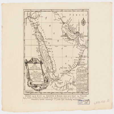
20. Carte de la coste d'Arabie, Mer Rouge et Golfe de Persetirée de la Carte de l'Océan Oriental publiée en 1740 par Ordre de Mgr le Comte de Maurepas augmentée sur des remarques particulières et dressée sur des observations astronomiques = Kaart van de Kust van Arabië, de Roode-Zee en de Gulf van Persië Gemaakt na de Fransse-Kaart van den Ooster-Ocean uitgegeven A. 1740 op Bevel van den Hre Grave de Maurepas Vermeederd op byzondere Aanmerkingen, en geschikt volgens Sterrekundige-Waarnemingen Creator: Schley, Jacobus van der, 1715-1779 (المنشئ) Date: Date Issued: between 1747 and 1767] Language: FrenchDutch Geographic region: Place of Production: ne, Netherlands, [HagueArabian Peninsula Extent: 1 map ; 24 x 21 cm.
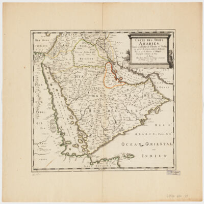
21. Carte des trois Arabiestirée en partie de l'Arabe de Nubie, en partie de diuers autres autheurs Creator: Sanson, Nicolas, 1600-1667 (المنشئ) Date: Date Issued: 1654 Language: French Geographic region: Place of Production: fr, France, ParisArabian Peninsula Extent: 1 map : hand col. ; 39 x 47 cm.
23. Département de Constantine, limites administratives Contributor: Algeria Service cartographique. Date: 1949 Language: French
24. Egypte, Nubie et Abyssinie. Creator: Malte-Brun, Conrad, 1775-1826 Date: ca. 1850 Language: French Geographic region: Egypt; Nubia; Sudan; South Sudan; Ethiopia; Africa
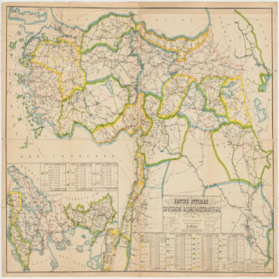
25. Empire Ottomandivision administrative Creator: Huber, R. (المنشئ) Date: Date Issued: 1899 Language: French Geographic region: Place of Production: fr, France, [S.l.]Turkey Extent: 1 map : col. ; 86 x 130 cm.
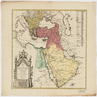
26. Empire de la Porte ottomane en Europe, en Asie et en Afrique avec les pays qui lui sont tributaires Creator: Lotter Brothers (Firm) (Creator) Date: Date Issued: [1790?] Language: French Geographic region: Place of Production: gw, Germany, AugsburgMiddle EastTurkeyEurope, SouthernAfrica, North Extent: 1 map : hand col. ; 47 x 55 cm.
27. Gardens of Cairo Creator: Delchevalerie, G. Date: 1899 Language: French Geographic region: Cairo; Egypt
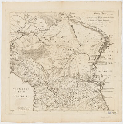
28. General Charte der Laender Zwischen dem Schwarzen und Caspischen MeereCircassien, Georgien, Armenien, Wüste von Astrachan und Caucasus hauptsoechlich die Grosse und Kleine Kabarda Creator: Treuttel, Jean-Georges, 1744-1826 (المنشئ) Date: Date Issued: [between 1765 and 1800?] Language: GermanFrench Geographic region: Place of Production: gw, Germany, StrasburgRussia (Federation)GeorgiaCaucasus, South Extent: 1 map ; 46 x 57 cm.
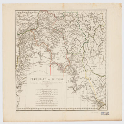
29. L' Euphrate et le Tigre Creator: Anville, Jean Baptiste Bourguignon d', 1697-1782 (المنشئ) Date: Date Issued: 1779 Language: FrenchLatin Geographic region: Place of Production: fr, France, [ParisEuphrates RiverTigris RiverIraqSyriaTurkey Extent: 1 map : hand col. ; 42 x 51 cm.
30. Le Kaire. Plan particulier de la ville Creator: Jomard, M. (Edme-François), 1777-1862 Date: 1809 - 1828 Language: French Geographic region: Cairo; Egypt
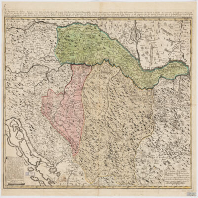
31. Le Royaume de Bosnie, dans son entier, dédié a son Excellence Monseignr. le feld Maréchal Comte de Khewenhüller Colonel d'un Régiment de Dragon Vice Roy d'Esclavonie, du Duché de Syrmie et Gouverneur de la Forteresse d'Essegg etc Creator: Briffaut, Étienne. (المنشئ) Date: Date Issued: 1740 Language: FrenchLatin Geographic region: Place of Production: fr, France, VienneBosnia and HerzegovinaCroatia Extent: 1 map : hand col. ; 60 x 90 cm.
32. Maps from "Cairo and its environs" Creator: Bénédite, Georges Aaron, 1857- Date: 1910 Language: EnglishFrench Geographic region: Cairo; Egypt
33. Maps from "Tārīkh al-barīd fī Miṣr" Creator: Egypt. Maṣlaḥat al-Barīd Date: 1934 Language: ArabicFrench Geographic region: Egypt
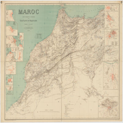
34. Maroc Creator: Flotte de Roquevaire, R. de. (المنشئ) Date: Date Issued: 1908 Language: French Geographic region: Place of Production: fr, France, ParisMoroccoAlgeriaWestern Sahara Extent: 1 map : col. ; 101 x 132 cm.
35. Oran : Algérie (Dept. D'Oran) Contributor: France Armée. Service géographique. Date: 1901 Language: French
36. Palestine ancienne & moderne d'après les sources les plus authentiques Creator: Andriveau-Goujon, E. (Eugène), 1832-1897 (المنشئ) Date: Date Issued: 1876 Language: FrenchLatinArabicHebrew Geographic region: Place of Production: fr, France, ParisPalestineLebanon Extent: 1 map : col. ; 62 x 46 cm.
37. Plan des Necropoles Thebaines Creator: E Baraize; Egypt. Maṣlaḥat al-Āthār Date: 1912 Language: French Geographic region: Thebes; Qinā; Egypt
38. Plan général de la Ville du Caire Creator: Grand, Pierre Bey Date: 1874 Language: French Geographic region: Cairo; Egypt
39. Royme., et désert de Barca et l'Égypte divisée en ses douze Cassifs, ou Gouvernemens Creator: Sanson, Nicolas, 1600-1667 (المنشئ) Date: Date Issued: 1655 Language: French Geographic region: Place of Production: fr, France, ParisEgyptLibya Extent: 1 map : hand col. ; 32 x 50 cm.
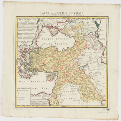
40. Turcia Asiaticaexhibens Natoliam modernam, in suos beglirbegatus divisam, itemque reliquos beglirbegatus, sive gubernationes et Prœfecturas generales, in regionibus Georgiæ, Armeniæ, Mespotamiæ, Syriæ et Arabiæ sitos, una cum Mari Nigro, Mari Azowiensi, Mari di Marmora, et Mari Ægeo, atque adiacentibus Insulis : C. P. S. C. M. = Carte de la Turquie asiatique contenant la Natolie moderne divisée en les beglerbeys & Creator: Homann Erben (Firm) (Creator) Date: Date Issued: 1771 Language: LatinFrench Geographic region: Place of Production: gw, Germany, NorimbergæMiddle EastTurkey Extent: 1 map : hand col. ; 44 x 51 cm.
41. Turquie d'Europe et partie de celle d'Asie divisée par grandes provinces et gouvernemts Creator: Janvier, Jean Denis (المنشئ) Date: Date Issued: [1760?] Language: French Geographic region: Place of Production: fr, France, BordeauxBalkan PeninsulaTurkeyThrace, Eastern (Turkey)
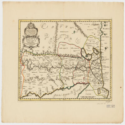
42. Ægyptus antiqua divisa in Nomos Creator: Duval, P. (Pierre), 1619-1682 (Creator) Date: Date Issued: 1652?] Language: LatinFrench Geographic region: Place of Production: ne, Netherlands, [AmsterdamEgypt Extent: 1 map : hand col. ; 35 x 50 cm.
45. Sketch map of Balkan Province, Turkmenistan Date: 1870/1880 Language: French Geographic region: Balkan Province Extent: 1 map