1. A generall mapp of the Coast of Barbarie, where in are the Kingdoms, and Estates of Morocco, Fez, Algiers, Tunis and Tripolialso the Kingdoms, Estates and Deserts of Barca, Egipt, Libya, Biledulgerid, Segelmesse and Darha: with the circumjacent counteries Creator: Sanson, Nicolas, 1600-1667 (المنشئ) Date: Date Issued: 1667?] Language: EnglishFrench Geographic region: Place of Production: enk, England, [LondonMoroccoTunisiaAlgeriaMauritania Extent: 1 map on 2 sheets ; 28 x 106 cm, sheets 35 x 57 cm and 35 x 59 cm.
2. A generall mapp of the Coast of Barbarie, where in are the Kingdoms, and Estates of Morocco, Fez, Algiers, Tunis and Tripolialso the Kingdoms, Estates and Deserts of Barca, Egipt, Libya, Biledulgerid, Segelmesse and Darha: with the circumjacent counteries Creator: Sanson, Nicolas, 1600-1667 (المنشئ) Date: Date Issued: 1667?] Language: EnglishFrench Geographic region: Place of Production: enk, England, [LondonMoroccoTunisiaAlgeriaMauritania Extent: 1 map on 2 sheets ; 28 x 106 cm, sheets 35 x 57 cm and 35 x 59 cm.
3. Africa, ca. 1680-1689 (Raster Image) Date: 201202 Geographic region: Africa116.36916252.713700-49.459512-86.118662
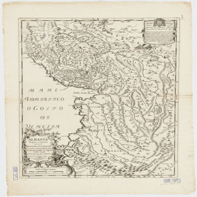
4. Albania Propria ouero Superiore detta anche Macedonia Occidentale Creator: Cantelli da Vignola, Giacomo, 1643-1719 (المنشئ) Date: Date Issued: 1689 Language: Italian Geographic region: Place of Production: it, Italy, RomaAlbania Extent: 1 map : 52 x 42 cm.
5. Books of the Torah Date: 1697 Language: Arabic Medium: manuscripts (document genre) Extent: 434 p.; 21.3 x 16 cm.
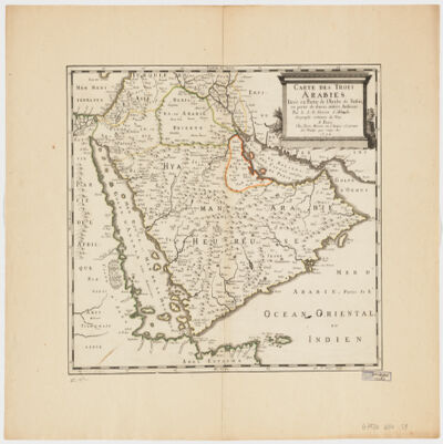
6. Carte des trois Arabiestirée en partie de l'Arabe de Nubie, en partie de diuers autres autheurs Creator: Sanson, Nicolas, 1600-1667 (المنشئ) Date: Date Issued: 1654 Language: French Geographic region: Place of Production: fr, France, ParisArabian Peninsula Extent: 1 map : hand col. ; 39 x 47 cm.
7. Colophon Date: 1081 AH/AD 1670 (Ottoman) Medium: ink and pigments on cream-colored, watermarked laid European paper Extent: Dimensions: H: 7 7/8 x W: 4 15/16 in. (20 x 12.5 cm)
8. Delineatio regionis Bassora cum pagis fluminibus et insulis, quæ christiani sancti Ioannis incolunt Creator: Dapper, Olfert, 1635 or 1636-1689 (المنشئ) Date: Date Issued: 1680?] Language: Latin Geographic region: Place of Production: ne, Netherlands, [AmsterdamIraqBaṣrah Region (Iraq) Extent: 1 map : hand col. ; 29 x 36 cm.
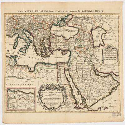
9. Estats de l'Empire du grand Seigneur des Turcs en Europe, en Asie, et en Afriquedivisé en tous ses Beglerbeglicz ou Gouvernements; où sont aussi remarqués les Estats qui luy sont Tributaires Creator: Jaillot, Alexis Hubert, 1632?-1712 (المنشئ) Date: Date Issued: 1696 Language: Latin Geographic region: Place of Production: fr, France, ParisTurkeyMiddle EastAfrica, NorthEurope, SouthernNorth AfricaSouthern Europe Time period: Ottoman Empire, 1288-1918 Extent: 1 map : hand colored ; 44 x 60 cm
10. Hasan Asha Koklian Sabil-Kuttab Date: 1694 Geographic region: CairoEgypt Medium: slides (photographs)