1. ‘Trigonometrical Plan of the Island and Harbour of Bahrein, on the Arabian Side of the Gulf of Persia; by Lieutts. G.B. Brucks, and W.E. Rogers. Hon. E.I.C. Marine Service: 1825. Drawn by Lieutt. M. Houghton; Draughtsman Hon. E.I.C. Marine. Engraved by Bateman and Son’ Contributor: James Horsburgh (publisher)John Bateman (artist)Michael Houghton (artist)George Edward Brucks (surveyor) Date: 1828/1828 Language: English Geographic region: Bahrain Extent: 1 map
2. ‘Chart of the South Coast of the Persian Gulph from Shaum to Ul Umrah by Philip Maughan. 1821. Drawn by M. Houghton’ Contributor: Philip Maughan (surveyor)John M. Guy (surveyor)Robert Cogan (surveyor)Michael Houghton (artist) Date: 1821/1821 Language: English Geographic region: Rass el Khyma Extent: 1 map
3. ‘Trigonometrical Survey of the Arabian or Southern Side of the Persian Gulf By Lieutenants J.M. Guy & G.B. Brucks H.C. Marine. 1824. Drawn by Lieutt. M. Houghton Draughtsman H.C.M. Engraved by John Bateman. Sheet 3rd’ Contributor: George Edward Brucks (surveyor)John M. Guy (surveyor)Michael Houghton (artist)James Horsburgh (publisher)John Bateman (artist) Date: 1826/1826 Language: English Geographic region: QatarShatt al ʻArab Extent: 1 map
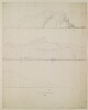
4. ‘Coast Views taken while employed on the Survey of the Arabian Side of the Gulf of Persia By Lieutenant M. Houghton, Draughtsman H.C. Marine’ Contributor: Michael Houghton (artist) Date: 1825/1825 Language: English Extent: 1 unpublished volume illustrated with 20 watercolour, pencil and pen and ink drawings
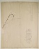
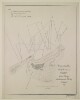
5. ‘Trigonometrical Plan of the Back-water at Amulgawein by Lieut.t G.B. Brucks under the direction of Lieut.t J.M. Guy, H.C.Marine. 1822’ Contributor: John M. Guy (surveyor)George Edward Brucks (surveyor)Michael Houghton (artist) Date: 1822/1822 Language: EnglishArabic Geographic region: Amulgawein Extent: 1 map
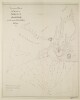
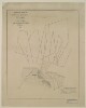
6. ‘Trigonometrical Plan of the Back-water of Debai by Lieut.t R. Cogan under the direction of Lt. J.M. Guy, H.C.Marine. 1822. Drawn by M. Houghton’ Contributor: Robert Cogan (surveyor)John M. Guy (surveyor)Michael Houghton (artist) Date: 1822/1822 Language: EnglishArabic Geographic region: Debai Extent: 1 map
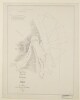
7. ‘Trigonometrical Plan of the Back-water at Sharja by Lieut.t R. Cogan under the direction of Lt. J.M. Guy, H.C.Marine. 1822’ Contributor: Robert Cogan (surveyor)Michael Houghton (artist)John M. Guy (surveyor) Date: 1822/1822 Language: EnglishArabic Geographic region: Sharjah Extent: 1 map
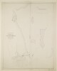
8. ‘Trigonometrical Plan of the Entrance of the Back-water at Aymaun by Lieut.t R. Cogan under the direction of Lt. J.M. Guy, H.C. Marine. 1822. Drawn by M. Houghton’ Contributor: Robert Cogan (surveyor)John M. Guy (surveyor)Michael Houghton (artist) Date: 1822/1822 Language: EnglishArabic Geographic region: Aymaun Extent: 1 map
9. ‘Trigonometrical Survey of the shores of, and the Soundings off the Entrance to Abothubbee Back-water on the Arabian side of the Persian Gulf by Lieut.s J.M. Guy and G.B. Brucks, H.C. Marine. 1823. Drawn by Lieut.t M. Houghton H.C.M.’ Contributor: Michael Houghton (artist)George Edward Brucks (surveyor)John M. Guy (surveyor) Date: 1823/1823 Language: English Geographic region: Abothubbee Extent: 1 map
10. Coastal Views of the Arabian Shores of the Persian Gulf Drawn by Lieutenant Michael Houghton Contributor: Michael Houghton (artist) Date: 1816/1826 Language: English Extent: 2 items