1. ‘Part of the Coast of Persia from Ras Tuloop to Bushire Surveyed by Lieutenants G.B. Brucks & R.Cogan, H.E.I.C. Marine. 1826. Engraved by Bateman and Son’ Contributor: James Horsburgh (publisher)John Bateman (artist)Robert Cogan (surveyor)George Edward Brucks (surveyor) Date: 1828/1828 Language: English Geographic region: Persian Gulf Extent: 1 map
2. ‘Part of the Cast of Arabia in the Gulf of Persia Surveyed by Lieut.ts J.M. Guy and G.B. Brucks assisted by Lieut.t R. Cogan H.C. Marine. 1822. Engraved by John Bateman. Sheet 1st' Contributor: Robert Cogan (surveyor)John M. Guy (surveyor)George Edward Brucks (surveyor)John Bateman (artist)James Horsburgh (publisher) Date: 1826/1826 Language: English Geographic region: Trucial Coast Extent: 1 map
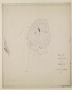
3. ‘Plan of the Island & Harbor of Beni Yass by Lieut.ts G.B. Brucks & R. Cogan. 1822’ Contributor: Robert Cogan (surveyor)George Edward Brucks (surveyor) Date: 1822/1822 Language: English Geographic region: Seer Beni Yass Extent: 1 map
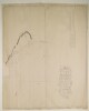
4. ‘Trigonometrical Plan of the Backwater at Ul Umrah on the Arabian side of the Persian Gulf by Lieut. R. Cogan under the direction of Lt. J.M. Guy, H.C. Marine, 1822’ Contributor: Robert Cogan (surveyor)John M. Guy (surveyor) Date: 1822/1822 Language: English Geographic region: Ul Umrah Extent: 1 map
5. ‘Trigonometrical Plan of Bushire Roads By Lieutenants G.B. Brucks and R.Cogan, H.E.I.C. Marine. 1826. Engraved by Bateman and Son’ Contributor: George Edward Brucks (surveyor)James Horsburgh (publisher)John Bateman (artist)Robert Cogan (surveyor) Date: 1828/1828 Language: English Geographic region: Bushire Extent: 1 map
6. ‘Chart of the South Coast of the Persian Gulph from Shaum to Ul Umrah by Philip Maughan. 1821. Drawn by M. Houghton’ Contributor: Philip Maughan (surveyor)John M. Guy (surveyor)Robert Cogan (surveyor)Michael Houghton (artist) Date: 1821/1821 Language: English Geographic region: Rass el Khyma Extent: 1 map
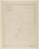
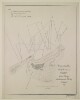
7. ‘Trigonometrical Plan of the Back-water of Debai by Lieut.t R. Cogan under the direction of Lt. J.M. Guy, H.C.Marine. 1822. Drawn by M. Houghton’ Contributor: Robert Cogan (surveyor)John M. Guy (surveyor)Michael Houghton (artist) Date: 1822/1822 Language: EnglishArabic Geographic region: Debai Extent: 1 map
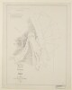
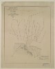
8. ‘Trigonometrical Plan of the Back-water at Sharja by Lieut.t R. Cogan under the direction of Lt. J.M. Guy, H.C.Marine. 1822’ Contributor: Robert Cogan (surveyor)Michael Houghton (artist)John M. Guy (surveyor) Date: 1822/1822 Language: EnglishArabic Geographic region: Sharjah Extent: 1 map
9. ‘Trigonometrical Plan of the Entrance of the Back-water at Aymaun by Lieut.t R. Cogan under the direction of Lt. J.M. Guy, H.C. Marine. 1822. Drawn by M. Houghton’ Contributor: Robert Cogan (surveyor)John M. Guy (surveyor)Michael Houghton (artist) Date: 1822/1822 Language: EnglishArabic Geographic region: Aymaun Extent: 1 map