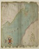
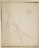
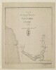
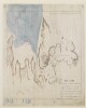
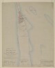
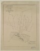
1. Chart of the Strait of Babellmandell made by John Friend Against ye East India hous in leaden hall Street London An.o Dn.o 1714 Date: 1714/1714 Language: English Geographic region: Babelmandel Extent: 1 map
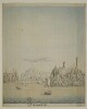
2. 'View of Muscat, entrance of Persian Gulph' Date: 1787/1787 Language: English Geographic region: Muscat Extent: 1 view
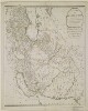
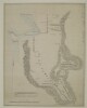
3. 'A New Map of the Empire of Persia from Monsr. D'Anville, First Geographer to the most Christian King, with Several Additions and Emendations' Contributor: Laurie & Whittle, Publishers and publishing (publisher)Jean Baptiste Bourgignon d'Anville (publisher) Date: 1794/1794 Language: English Geographic region: Persia Extent: 1 map sheet
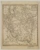
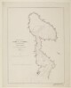
5. ‘Indiae Veteris Quatenus Macedonibus Nota Fuit Finitimarumque Regionum Specimen Geographicum’ Date: 1797/1797 Language: English Extent: 1 map sheet
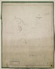
7. Four nautical charts related to the Persian Gulf and Gulf of Oman Contributor: Frederic Charles Danvers (attributed name) Date: 1800/1899 Language: Dutch Extent: 4 manuscript charts
8. Charts of the Gulf of Oman and Strait of Hormuz Date: 1800/1899 Language: Dutch Geographic region: Gulf of Oman Extent: 3 maps on 1 sheet
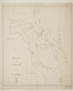
9. Chart of the Gulf of Oman Date: 1800/1899 Language: Dutch Geographic region: Gulf of Oman Extent: 1 map
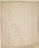
10. Nautical chart of the Persian Gulf Date: 1800/1899 Language: Dutch Geographic region: Persian Gulf Extent: 1 map
11. Chart of the Persian Gulf Date: 1800/1899 Language: Dutch Geographic region: Persian Gulf Extent: 1 map
12. East India or China Pilot, containing 126 charts chiefly published by James Horsburgh Contributor: James Horsburgh (publisher) Date: 1800/1899 Language: English Extent: 126 maps
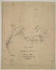
13. ‘Route of Lieut. McDonald 12th N.I. Ensign Monteith Engineers. Performed by Order of Brigadier General Malcolm Ambassador to the Court of Persia’ Contributor: John Garstin (signer) Date: 1806/1816 Language: English Geographic region: Iran Extent: 1 map sheet
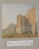
15. ‘Abou-Shehr or Bushire, Persian Gulf’ / ‘On the road to Dalkin [Daliki] from Bushire showing the mirage’ by Joseph D'Arcy (1780–1846) Contributor: Joseph D'Arcy (artist) Date: 1810/1812 Language: English Geographic region: Bushire Extent: 1 watercolour drawing on paper
16. ‘Route from Isfahan by Kermanshah to Muraga and return by Hamadan. Performed under Orders of Brigr. Genl. Malcolm by Lieut. E. Frederick of the Bombay Military Establishmt. AD. 1810’ Contributor: John Garstin (signer) Date: 1810/1810 Language: EnglishLatin Geographic region: Iran Extent: 1 map sheet
17. ‘The Camp at Dalkie [Daliki] on the Road from Bushire to Shiraz’ by Joseph D'Arcy (1780–1846) Contributor: Joseph D'Arcy (artist) Date: 1810/1812 Language: English Extent: 1 watercolour drawing on paper
18. ‘Sketch of Lieutt. Snodgrass’s Route from Bushire to Shiraz, via Feruzabad, A.D. 1810’ Contributor: John Garstin (signer) Date: 1810/1810 Language: English Geographic region: Iran Extent: 1 map sheet
19. ‘Colonel D’arcy Drawings Made During the Embassy to Persia 1810–12’ by Joseph D’Arcy (1780–1846) Contributor: Joseph D'Arcy (artist) Date: 1810/1812 Language: English Geographic region: AzerbaijanPersiaTurkeyArmenia Extent: Album of 58 watercolour drawings of views of Persia, Azerbaijan, Armenia and Turkey, mostly made during the Ouseley embassy to Tehran (1810–12), 1 newspaper cutting, 2 notes and 2 handlists (c. 1880) lightly tipped into a leather-bound album.
20. ‘Entering the Kotils from Bushire’ by Joseph D'Arcy (1780–1846) Contributor: Joseph D'Arcy (artist) Date: 1810/1812 Language: English Extent: 1 watercolour drawing on paper
21. ‘Scene entering the Kotils from Bushire’ by Joseph D'Arcy (1780–1846) Contributor: Joseph D'Arcy (artist) Date: 1810/1812 Language: English Geographic region: Bushire Extent: 1 watercolour drawing on paper
23. ‘Route of Lieut. McDonald 12th N.I. Ensign Monteith Engineers. Performed by Order of Brigr. Genl. Malcolm Embassador to the Court of Persia. W. Monteith Ensgn Engineers' Contributor: John Garstin (signer) Date: 1811/1811 Language: English Geographic region: Iran Extent: 1 map sheet
24. ‘Sketch of the Roads Between Constantinople and Dehli compiled from the Travels of Monsr. Tavernier Mr Forster and from other Sources’ Date: 1813/1813 Language: English Geographic region: Middle East Extent: 1 map sheet
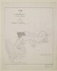
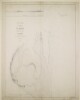
25. ‘Khor as Shem. Surveyed in 1821 by Lieut Guy I.N., additions by Comm. Constable’ Contributor: John M. Guy (surveyor)C.G. Constable (surveyor) Date: 1816/1826 Language: English Geographic region: Khasab Bay Extent: 1 map sheet
26. ‘Sketch of the Arabian Coast between Raumps & Ras el Khyma: in 5 fathoms. Drawn by M. Houghton’ Date: 1816/1826 Language: English Geographic region: Rass el Khyma Extent: 1 view
27. ‘Coast of Arabia: taken at anchor in 15 fathoms about a mile distant from Shaum. Drawn by M. Houghton’ Date: 1816/1826 Language: English Geographic region: Shaum Extent: 1 view
28. 'Route across Arabia from El Katif in the Persian Gulf to Yambo in the Red Sea. Completed from the fournal [journal] of Capt. Sadleir' Date: 1816/1826 Language: English Extent: 1 map sheet
29. Coastal Views of the Arabian Shores of the Persian Gulf Drawn by Lieutenant Michael Houghton Contributor: Michael Houghton (artist) Date: 1816/1826 Language: English Extent: 2 items
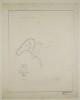
30. ‘A Plan of the Backwater of Rassulkyma with the Soundings off the Entrance by Lieut.t Brucks’ Contributor: George Edward Brucks (surveyor) Date: 1817/1827 Language: English Geographic region: Rass el Khyma Extent: 1 map
31. 'Plan of the attack of Ras Ul Khyma by the force under Sir Willm. Gr. Keir K.M.T., between the 3rd & 9th of December 1819’ Date: 1819/1819 Language: English Geographic region: Ra's al-Khaymah Extent: 1 plan sheet
33. ‘Chart of the South Coast of the Persian Gulph from Shaum to Ul Umrah by Philip Maughan. 1821. Drawn by M. Houghton’ Contributor: Philip Maughan (surveyor)John M. Guy (surveyor)Robert Cogan (surveyor)Michael Houghton (artist) Date: 1821/1821 Language: English Geographic region: Rass el Khyma Extent: 1 map
34. ‘Trigonometrical Plan of the Summits of the Quoins & Islands that form what is commonly called Cape Musseldom on the Southern side of the Entrance to the Persian Gulf by P. Maughan, Commander in the H.C. Marine. 1821’ Contributor: Philip Maughan (surveyor) Date: 1821/1821 Language: English Geographic region: Musandam Peninsula Extent: 1 map
35. ‘Persian Gulf single charts.–Memoir.–Lieut. Houghton’ Contributor: Commander of the survey-ship Discovery (author)Michael Houghton (author) Date: 1822/1822 Language: English Geographic region: RaumpsRasel KhymaAymaunSharjaDebayMoosendemAmulgaweinShaumUl Umrah Extent: 1 volume (24 folios)
36. ‘Plan of the Island & Harbor of Beni Yass by Lieut.ts G.B. Brucks & R. Cogan. 1822’ Contributor: Robert Cogan (surveyor)George Edward Brucks (surveyor) Date: 1822/1822 Language: English Geographic region: Seer Beni Yass Extent: 1 map
37. ‘SKETCH OF THE ISLAND OF KENN, In the Persian Gulf. Thos. Remon, Captn., Engineers’ Contributor: James Orton (correspondent)Francis Warden (correspondent) Date: 1822/1822 Language: English Geographic region: Kenn IslandMuscatBahrainKuwaitTrucial StatesQatarSitrahSitraBūshehrAbū-ShahrHormuz Isle Extent: 1 map sheet
38. ‘Trigonometrical plan of the backwater at Ras Al Khyma. By Lieut. J.M. Guy, drawn by M. Houghton’ Contributor: John M. Guy (surveyor)Michael Houghton (surveyor) Date: 1822/1822 Language: English Geographic region: Ra's al-Khaymah Extent: 1 map sheet
39. 'Sketch Map shewing the Routes between Constantinople and India by John Walker’ Contributor: J & C Walker, engravers (publisher)John Walker (publisher) Date: 1822/1832 Language: English Geographic region: Middle East Extent: 1 map sheet
40. ‘Trigonometrical Plan of the Back-water at Amulgawein by Lieut.t G.B. Brucks under the direction of Lieut.t J.M. Guy, H.C.Marine. 1822’ Contributor: John M. Guy (surveyor)George Edward Brucks (surveyor)Michael Houghton (artist) Date: 1822/1822 Language: EnglishArabic Geographic region: Amulgawein Extent: 1 map
41. ‘Trigonometrical Plan of the Back-water of Debai by Lieut.t R. Cogan under the direction of Lt. J.M. Guy, H.C.Marine. 1822. Drawn by M. Houghton’ Contributor: Robert Cogan (surveyor)John M. Guy (surveyor)Michael Houghton (artist) Date: 1822/1822 Language: EnglishArabic Geographic region: Debai Extent: 1 map
42. ‘Trigonometrical Plan of the Back-water at Sharja by Lieut.t R. Cogan under the direction of Lt. J.M. Guy, H.C.Marine. 1822’ Contributor: Robert Cogan (surveyor)Michael Houghton (artist)John M. Guy (surveyor) Date: 1822/1822 Language: EnglishArabic Geographic region: Sharjah Extent: 1 map
43. ‘Trigonometrical Plan of the Entrance of the Back-water at Aymaun by Lieut.t R. Cogan under the direction of Lt. J.M. Guy, H.C. Marine. 1822. Drawn by M. Houghton’ Contributor: Robert Cogan (surveyor)John M. Guy (surveyor)Michael Houghton (artist) Date: 1822/1822 Language: EnglishArabic Geographic region: Aymaun Extent: 1 map
44. ‘Trigonometrical survey of Core Alladeid on the Arabian side of the Gulf of Persia. By Lieuts. J. M. Guy and G. B. Brucks, H. C. Marine. Drawn by Lieut. M. Houghton, H.C.M.’ Contributor: George Edward Brucks (surveyor)John M. Guy (surveyor)Michael Houghton (surveyor) Date: 1823/1823 Language: English Geographic region: Khawr al 'Udayd Extent: 1 map sheet
45. ‘Trigonometrical plan of the harbour of El Biddah on the Arabian side of the Persian Gulf. By Lieuts. J. M. Guy and G. B. Brucks, H. C. Marine. Drawn by Lieut. M. Houghton’ Contributor: George Edward Brucks (surveyor)John M. Guy (surveyor)Michael Houghton (surveyor) Date: 1823/1823 Language: English Geographic region: El Biddah Extent: 1 map sheet
46. ‘Trigonometrical plan of Core Shedeitch on the Arabian side of the Persian Gulf. By Lieutenants J. M. Guy and G. B. Brucks, H. C. Marine. Drawn by Lieut. M. Houghton’ Date: 1823/1823 Language: English Extent: 1 map sheet
47. ‘Trigonometrical Survey of the shores of, and the Soundings off the Entrance to Abothubbee Back-water on the Arabian side of the Persian Gulf by Lieut.s J.M. Guy and G.B. Brucks, H.C. Marine. 1823. Drawn by Lieut.t M. Houghton H.C.M.’ Contributor: Michael Houghton (artist)George Edward Brucks (surveyor)John M. Guy (surveyor) Date: 1823/1823 Language: English Geographic region: Abothubbee Extent: 1 map
48. ‘Ul Umrah from the anchorage’ Date: 1825/1825 Language: English Geographic region: Ul Umrah Extent: 1 watercolour view
49. ‘Coast between Bookh & Shaum’ Date: 1825/1825 Language: English Geographic region: Shaum Extent: 1 watercolour view
50. ‘Coast from Raumps to Ras-al-Khyma’ Date: 1825/1825 Language: English Geographic region: Ras Al Khyma Extent: 1 watercolour view
51. ‘Coast from Jezeerat Gunnum to Ras Sheik Munsoud’ Date: 1825/1825 Language: English Geographic region: Ras Moosendem Extent: 1 watercolour view
52. ‘Coast from Ras Sheik Munsood to Shaum’ Date: 1825/1825 Language: English Geographic region: Ras Moosendem Extent: 1 watercolour view
53. ‘Coast from Ras Moosendem to Perforated Rock’ Date: 1825/1825 Language: English Geographic region: Ras Moosendem Extent: 1 watercolour view
54. ‘Sharga in 6 ½ fathoms’ Date: 1825/1825 Language: English Geographic region: Sharga Extent: 1 watercolour view
55. ‘Northern Entrance to Discovery Strait, from the anchorage in 15 fms. within’ Date: 1825/1825 Language: English Geographic region: Discovery Strait Extent: 1 watercolour view
56. ‘Jirnain Island from the Westward dis.t 1 ¾ miles. Drawn by Lieut.t M. Houghton from a Sketch by Dr. Mackell’ Date: 1825/1825 Language: English Geographic region: Jirnain Island Extent: 1 watercolour view
57. ‘Zircooa Island from the Eastward dist.t about 2 miles. From a Sketch by Dr Mackell’ Date: 1825/1825 Language: English Geographic region: Zircooa Island Extent: 1 watercolour view
58. ‘Seer Beni Yass dist.t 6 ¼ miles. From a Sketch by Dr. Mackell’ Date: 1825/1825 Language: English Geographic region: Seer Beni Yass Extent: 1 watercolour view
59. ‘Debay in 6 ½ fathoms’ Date: 1825/1825 Language: English Geographic region: Debay Extent: 1 watercolour view
60. ‘Arabic Characters to Accompany and for Insertion in the Chart of the Persian Gulf’ Date: 1825/1825 Language: EnglishArabic Extent: 1 item
61. ‘Coast of Arabia' showing Jibbul Hadwareeah and Zerboot. From a Sketch by Dr. Mackell Date: 1825/1825 Language: English Extent: 1 watercolour view
62. ‘Aymaun in five fathoms’ Date: 1825/1825 Language: English Geographic region: Aymaun Extent: 1 watercolour view
63. ‘Museldom from the Westw.d’ Date: 1825/1825 Language: English Geographic region: Museldom Island Extent: 1 watercolour view
64. ‘Coast Views taken while employed on the Survey of the Arabian Side of the Gulf of Persia By Lieutenant M. Houghton, Draughtsman H.C. Marine’ Contributor: Michael Houghton (artist) Date: 1825/1825 Language: English Extent: 1 unpublished volume illustrated with 20 watercolour, pencil and pen and ink drawings
65. Coast from Raumps to Ras-al-Khyma. 'Continuation' Date: 1825/1825 Language: English Extent: 1 watercolour view
66. Coast from Jezeerat Gunnum to Ras Sheik Munsoud. ‘Continuation’ Date: 1825/1825 Language: English Geographic region: Ras Moosendem Extent: 1 watercolour view
67. Coast from Ras Moosendem to Perforated Rock. 'Continuation' Date: 1825/1825 Language: English Geographic region: Ras Moosendem Extent: 1 watercolour view
68. ‘Arabian Coast in 5 fathoms' showing Seir Beni Yass, Zerboot and Jibbul Hadwareeah. Drawn by Lieutt. M. Houghton, Draughtsman to the Marine, from a Sketch by Dr. Mackell Date: 1825/1825 Language: English Geographic region: Seer Beni Yass Extent: 1 watercolour view
69. View of the coastline between Seer Beni Yass and Jibbul el Woteid. 'Drawn by M. Houghton, from a Sketch by A. Mackell Esqre. A.S.' Date: 1825/1825 Language: English Geographic region: Seer Beni Yass Extent: 1 watercolour view
70. Part of the Cast of Arabia in the Gulf of Persia Surveyed by Lieut.ts J.M. Guy and G.B. Brucks assisted by Lieut.t R. Cogan H.C. Marine. 1822. ‘Engraved by John Bateman. Sheet 2nd' Contributor: James Horsburgh (publisher)John Bateman (artist) Date: 1826/1826 Language: English Geographic region: Trucial Coast Extent: 1 map
71. ‘Part of the Cast of Arabia in the Gulf of Persia Surveyed by Lieut.ts J.M. Guy and G.B. Brucks assisted by Lieut.t R. Cogan H.C. Marine. 1822. Engraved by John Bateman. Sheet 1st' Contributor: Robert Cogan (surveyor)John M. Guy (surveyor)George Edward Brucks (surveyor)John Bateman (artist)James Horsburgh (publisher) Date: 1826/1826 Language: English Geographic region: Trucial Coast Extent: 1 map
72. ‘Trigonometrical Survey of the Arabian or Southern Side of the Persian Gulf By Lieutenants J.M. Guy & G.B. Brucks H.C. Marine. 1824. Drawn by Lieutt. M. Houghton Draughtsman H.C.M. Engraved by John Bateman. Sheet 3rd’ Contributor: George Edward Brucks (surveyor)John M. Guy (surveyor)Michael Houghton (artist)James Horsburgh (publisher)John Bateman (artist) Date: 1826/1826 Language: English Geographic region: QatarShatt al ʻArab Extent: 1 map
73. ‘Part of the Coast of Persia from Ras Tuloop to Bushire Surveyed by Lieutenants G.B. Brucks & R.Cogan, H.E.I.C. Marine. 1826. Engraved by Bateman and Son’ Contributor: James Horsburgh (publisher)John Bateman (artist)Robert Cogan (surveyor)George Edward Brucks (surveyor) Date: 1828/1828 Language: English Geographic region: Persian Gulf Extent: 1 map
74. ‘Part of the Arabian side of the Persian Gulf; from Core Abdullah to Ras Reccan, Surveyed by Lieutenants J.M. Guy, G.B. Brucks, & W.E. Rogers, H.E.I.Cs. Marine, 1825. Engraved by Bateman & Son. Sheet 1st and 5th of the Survey of the Arabian Coast’ Contributor: James Horsburgh (publisher)John M. Guy (surveyor)George Edward Brucks (surveyor)John Bateman (artist) Date: 1828/1828 Language: English Geographic region: Kuwait Extent: 1 map
75. ‘Trigonometrical Plan of the Island and Harbour of Bahrein, on the Arabian Side of the Gulf of Persia; by Lieutts. G.B. Brucks, and W.E. Rogers. Hon. E.I.C. Marine Service: 1825. Drawn by Lieutt. M. Houghton; Draughtsman Hon. E.I.C. Marine. Engraved by Bateman and Son’ Contributor: James Horsburgh (publisher)John Bateman (artist)Michael Houghton (artist)George Edward Brucks (surveyor) Date: 1828/1828 Language: English Geographic region: Bahrain Extent: 1 map
76. ‘Plan of the Anchorage off the Town of El Katiff on the Arabian Side of the Persian Gulf by Lieutenants G.B. Brucks and W.E. Rogers H.E.I.C. Marine. 1825. Engraved by Bateman and Son’ Contributor: James Horsburgh (publisher)John Bateman (artist)George Edward Brucks (surveyor) Date: 1828/1828 Language: English Geographic region: Qatif Extent: 1 map
77. ‘Trigonometrical Plan of Bushire Roads By Lieutenants G.B. Brucks and R.Cogan, H.E.I.C. Marine. 1826. Engraved by Bateman and Son’ Contributor: George Edward Brucks (surveyor)James Horsburgh (publisher)John Bateman (artist)Robert Cogan (surveyor) Date: 1828/1828 Language: English Geographic region: Bushire Extent: 1 map
78. ‘Trigonometrical Plan of the Harbour of Grane or Quade in the Gulf of Persia By Lieutts. J.M. Guy and G.B. Brucks H.E.I.C. Marine. 1825. Engraved by Bateman and Son’ Contributor: George Edward Brucks (surveyor)John M. Guy (surveyor)James Horsburgh (publisher)John Bateman (artist) Date: 1828/1828 Language: English Geographic region: Kuwait Bay Extent: 1 map
79. Three views of the coastal towns of Hodeida, Loheia and El Cassar by Thomas Elwon (1793/4–1835) Contributor: Thomas Elwon (artist) Date: 1829/1834 Language: English Geographic region: LoheiaHodeida Extent: 3 topographical, watercolour views on 1 sheet of paper
80. Part of the Arabian side of the Persian Gulf; from Core Abdullah to Ras Reccan, Surveyed by Lieutenants J.M. Guy, G.B. Brucks, & W.E. Rogers, H.E.I.Cs. Marine, 1825. ‘Sheet, 2 and 4. Engraved by R. Bateman’ Contributor: James Horsburgh (publisher)John Bateman (artist) Date: 1829/1829 Language: English Geographic region: Al-HasaBahrainQatarShatt al ʻArab Extent: 1 map
81. Drawings of the coast around Aden and along the Red Sea made during Elwon’s survey to establish the best course for steamers travelling to and from Suez by Thomas Elwon (1793/4-1835) Contributor: Thomas Elwon (artist) Date: 1829/1834 Language: English Geographic region: Babelmandel Extent: 9 topographical views on 4 sheets of paper
82. Drawings of the coast around Aden and along the Red Sea made during Elwon’s survey to establish the best course for steamers travelling to and from Suez by Thomas Elwon (1793/4-1835) Date: 1829/1834 Language: English Extent: 9 topographical views on four sheets of paper
83. Six views of the Red Sea coastline and flysheet of a sketchbook by Thomas Elwon (1793/4–1835) Contributor: Thomas Elwon (artist) Date: 1829/1834 Language: English Geographic region: Babelmandel Extent: 6 partial pencil drawings and flysheet of sketchbook on two sheets of paper
84. View of a coastal town by Thomas Elwon (1793/4–1835) Contributor: Thomas Elwon (artist) Date: 1829/1834 Language: English Geographic region: Hodedda Extent: 4 topographical views on 1 sheet of paper
85. View of Suakin and of a peak on the Red Sea coast by Thomas Elwon (1793/4–1835) Contributor: Thomas Elwon (artist) Date: 1829/1834 Language: English Extent: 2 partial pencil drawings on paper
86. View of Hodedda [Al Hodeida] and a fort by Thomas Elwon (1793/4–1835) Contributor: Thomas Elwon (artist) Date: 1829/1834 Language: English Geographic region: Hodedda Extent: 2 topographical views on 1 sheet of paper
87. Two views of the Red Sea coastline by Thomas Elwon (1793/4–1835) Contributor: Thomas Elwon (artist) Date: 1829/1834 Language: English Extent: 2 partial pencil drawings on paper
88. Two views of the Red Sea coastline by Thomas Elwon (1793/4–1835) Contributor: Thomas Elwon (artist) Date: 1829/1834 Language: English Extent: 2 partial pencil drawings on paper
89. Two views of the Red Sea coastline by Thomas Elwon (1793/4–1835) Contributor: Thomas Elwon (artist) Date: 1829/1834 Language: English Extent: 2 partial pencil drawings on paper
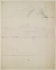
90. Two views of the coast of Babelmandel Cape [Ras Bab-el-Mandeb] by Thomas Elwon (1793/4–1835) Contributor: Thomas Elwon (artist) Date: 1829/1834 Language: English Geographic region: Babelmandel Extent: 2 sequential, topographical, watercolour views on 1 sheet of paper
91. ‘Chart Intended as an Accompaniment to the Book of Directions for Navigating to, from, and in the East Indies. Engraved by John Bateman’ Contributor: John Bateman (artist)James Horsburgh (publisher) Date: 1830/1830 Language: English Geographic region: Arabian Sea Extent: 1 map
92. ‘Battnah or Burka Coast. Engraved by Richard Bateman’ Contributor: Richard Bateman (artist)James Horsburgh (publisher) Date: 1831/1831 Language: English Geographic region: Batinah Coast Extent: 1 map
93. ‘The Coast from Bushire to Basadore, in the Persian Gulf, Surveyed by Lieuts. G.B. Brucks & S.B. Haines, H.C. Marine 1828. Engraved by R. Bateman 43 Hart St. Bloomsbury’ Contributor: George Edward Brucks (surveyor)Stafford Bettesworth Haines (surveyor)Richard Bateman (artist)James Horsburgh (publisher) Date: 1831/1831 Language: English Geographic region: Persian Gulf Extent: 2 maps on 1 sheet
94. ‘The Entrance to the Gulf of Persia; and Coast of Arabia from Ras Goberindee to Muscat. Surveyed by Com.r G.B. Brucks, and Lt. S.B. Haines, H.C. Marine, 1828. Engraved by Richard Bateman’ Contributor: George Edward Brucks (surveyor)Stafford Bettesworth Haines (surveyor)Richard Bateman (artist)James Horsburgh (publisher) Date: 1831/1831 Language: English Geographic region: Strait of Hormuz Extent: 1 map
95. ‘Trigonometrical Survey of the Entrances to the Rivers at the Head of the Persian Gulf by Lieuts. G.B. Brucks, & S.B. Haines, H.C. Marine, 1827. Engraved by Richard Bateman’ Contributor: James Horsburgh (publisher)Richard Bateman (artist)Stafford Bettesworth Haines (surveyor)George Edward Brucks (surveyor) Date: 1831/1831 Language: English Geographic region: Persian Gulf Extent: 1 map
96. ‘Trigonometrical Survey of Clarence’s Strait, Gulf of Persia. By Commr. G.B. Brucks and Lieutt. S.B. Haines. H.C. Marine 1828. Engraved by R. Bateman. Sheet 1st’ Contributor: George Edward Brucks (surveyor)Stafford Bettesworth Haines (surveyor)Richard Bateman (artist)James Horsburgh (publisher) Date: 1831/1831 Language: English Geographic region: KishmClarence Strait Extent: 1 map