1. A generall mapp of the Coast of Barbarie, where in are the Kingdoms, and Estates of Morocco, Fez, Algiers, Tunis and Tripolialso the Kingdoms, Estates and Deserts of Barca, Egipt, Libya, Biledulgerid, Segelmesse and Darha: with the circumjacent counteries Creator: Sanson, Nicolas, 1600-1667 (المنشئ) Date: Date Issued: 1667?] Language: EnglishFrench Geographic region: Place of Production: enk, England, [LondonMoroccoTunisiaAlgeriaMauritania Extent: 1 map on 2 sheets ; 28 x 106 cm, sheets 35 x 57 cm and 35 x 59 cm.
2. A generall mapp of the Coast of Barbarie, where in are the Kingdoms, and Estates of Morocco, Fez, Algiers, Tunis and Tripolialso the Kingdoms, Estates and Deserts of Barca, Egipt, Libya, Biledulgerid, Segelmesse and Darha: with the circumjacent counteries Creator: Sanson, Nicolas, 1600-1667 (المنشئ) Date: Date Issued: 1667?] Language: EnglishFrench Geographic region: Place of Production: enk, England, [LondonMoroccoTunisiaAlgeriaMauritania Extent: 1 map on 2 sheets ; 28 x 106 cm, sheets 35 x 57 cm and 35 x 59 cm.
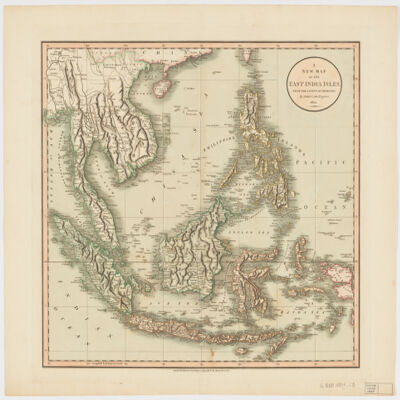
3. A new map of the East India Islesfrom the latest authorities Creator: Cary, John, approximately 1754-1835 (المنشئ) Date: Date Issued: Dec. 21, 1801 Language: English Geographic region: Place of Production: enk, England, LondonSoutheast AsiaEast IndiesIndonesiaMalay PeninsulaIndochinaPhilippines Extent: 1 map : hand col. ; 44 x 50 cm.
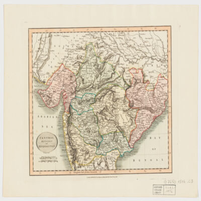
4. Central division of Hindoostan Creator: Cary, John, approximately 1754-1835 (المنشئ) Date: Date Issued: June 1, 1816 Language: English Geographic region: Place of Production: enk, England, LondonIndia Extent: 1 map : hand col. ; 22 x 27 cm.
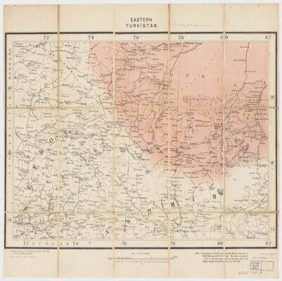
5. Eastern Turkistan Creator: Survey of India (المنشئ) Date: Date Issued: Feb. 1908 Language: English Geographic region: Place of Production: ii, India, [Calcutta]Asia, CentralXinjiang Uygur Zizhiqu (China)Northern Areas (Pakistan)North-West Frontier Province (Pakistan)Jammu and Kashmir (India) Extent: 1 map : col. ; 34 x 48 cm.
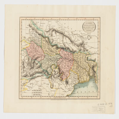
6. Gangetic Hindoostan or the countries occupied by the Ganges and the branches Creator: Cary, John, approximately 1754-1835 (المنشئ) Date: Date Issued: June 1, 1816 Language: English Geographic region: Place of Production: enk, England, LondonIndia, NortheasternBangladeshNepal Extent: 1 map : hand col. ; 22 x 27 cm.
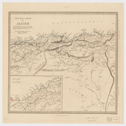
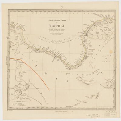
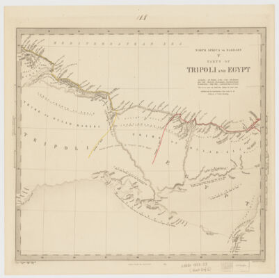
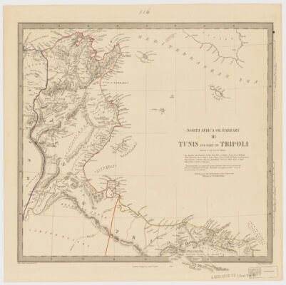
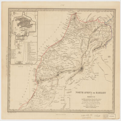
7. North Africa or Barbary Creator: Society for the Diffusion of Useful Knowledge (Great Britain) (المنشئ) Date: Date Issued: Jan. 1st, 1853 Language: English Geographic region: Place of Production: uk, , LondonAfrica, North Extent: 5 maps : col. ; 30 x 37 cm. each, sheets 37 x 44 cm.
8. North Africa or Barbary Creator: Society for the Diffusion of Useful Knowledge (Great Britain) (المنشئ) Date: Date Issued: Jan. 1st, 1853 Language: English Geographic region: Place of Production: uk, , LondonAfrica, North Extent: 5 maps : col. ; 30 x 37 cm. each, sheets 37 x 44 cm.
9. North Africa or Barbary Creator: Society for the Diffusion of Useful Knowledge (Great Britain) (المنشئ) Date: Date Issued: Jan. 1st, 1853 Language: English Geographic region: Place of Production: uk, , LondonAfrica, North Extent: 5 maps : col. ; 30 x 37 cm. each, sheets 37 x 44 cm.
10. North Africa or Barbary Creator: Society for the Diffusion of Useful Knowledge (Great Britain) (المنشئ) Date: Date Issued: Jan. 1st, 1853 Language: English Geographic region: Place of Production: uk, , LondonAfrica, North Extent: 5 maps : col. ; 30 x 37 cm. each, sheets 37 x 44 cm.
11. North Africa or Barbary Creator: Society for the Diffusion of Useful Knowledge (Great Britain) (المنشئ) Date: Date Issued: Jan. 1st, 1853 Language: English Geographic region: Place of Production: uk, , LondonAfrica, North Extent: 5 maps : col. ; 30 x 37 cm. each, sheets 37 x 44 cm.
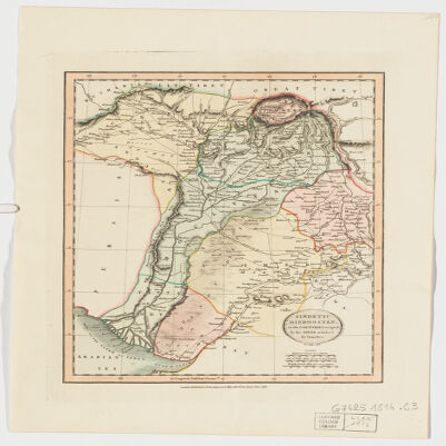
12. Sindetic Hindoostan or the countries occupied by the Sinde or Indus and its branches Creator: Cary, John, approximately 1754-1835 (المنشئ) Date: Date Issued: June 1, 1816 Language: English Geographic region: Place of Production: enk, England, LondonSouth Asia Extent: 1 map : hand col. ; 27 x 22 cm.
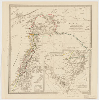
13. Syria Creator: Hughes, William, 1818-1876 (المنشئ) Date: Date Issued: Jan. 1st, 1853 Language: English Geographic region: Place of Production: uk, , LondonSyriaLebanon Extent: 1 map : col. ; 39 x 31 cm.
14. The Harvard collection of Ismaili literature in Indic languagesa descriptive catalog and finding aid Creator: Asani, Ali S. (Ali Sultaan), 1954- (المنشئ) Date: Date Issued: 1992 Language: English Geographic region: Place of Production: mau, Massachusetts, Boston, MassMassachusetts Extent: 689 p. ; 24 cm.
15. The Mahomedan law of succession to the property of intestatesin Arabick, engraved on copper plates from an ancient manuscript Creator: Ibn al-Mutafanninah, Muḥammad ibn ʻAlī, 1103 or 1104-1181 or 1182 (المنشئ) Date: Date Issued: 1782 Language: EnglishArabic Geographic region: Place of Production: enk, England, London Extent: [52] p. ; 26 cm.
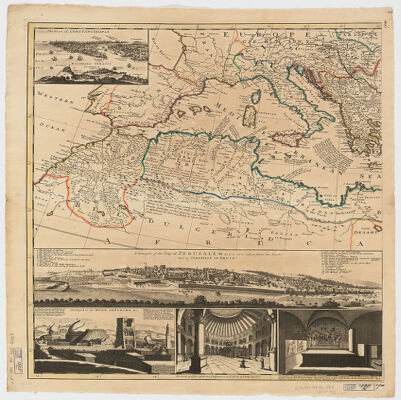
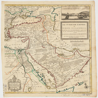
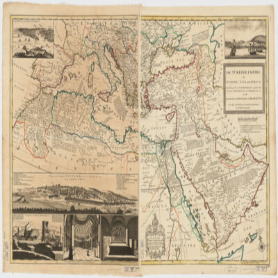
16. The Turkish Empire in Europe, Asia, and Africadividid into all its governments, together with the other territories that are tributary to it, as also the dominions of ye Emperor of Marocco [sic] according to the newest and most exact observations Creator: Moll, Herman, -1732 (المنشئ) Date: Date Issued: [1714?] Language: English Geographic region: Place of Production: enk, England, [London]TurkeyMediterranean Region Time period: Ottoman Empire, 1288-1918 Extent: 1 map on 2 sheets ; 61 x 101 cm, sheets 66 x 56 cm.
17. The Turkish Empire in Europe, Asia, and Africadividid into all its governments, together with the other territories that are tributary to it, as also the dominions of ye Emperor of Marocco [sic] according to the newest and most exact observations Creator: Moll, Herman, -1732 (المنشئ) Date: Date Issued: [1714?] Language: English Geographic region: Place of Production: enk, England, [London]TurkeyMediterranean Region Time period: Ottoman Empire, 1288-1918 Extent: 1 map on 2 sheets ; 61 x 101 cm, sheets 66 x 56 cm.
18. The Turkish Empire in Europe, Asia, and Africadividid into all its governments, together with the other territories that are tributary to it, as also the dominions of ye Emperor of Marocco [sic] according to the newest and most exact observations Creator: Moll, Herman, -1732 (المنشئ) Date: Date Issued: [1714?] Language: English Geographic region: Place of Production: enk, England, [London]TurkeyMediterranean Region Time period: Ottoman Empire, 1288-1918 Extent: 1 map on 2 sheets ; 61 x 101 cm, sheets 66 x 56 cm.
19. Translations of the Ottoman constitutional lawsthe Wilayet Administrative Law, the Municipal Law and various other laws Date: Date Issued: 1922] Language: EnglishTurkish, Ottoman (1500-1928) Geographic region: Place of Production: iq, Iraq, [BaghdadTurkey Extent: [5], 72 p. 34 cm.