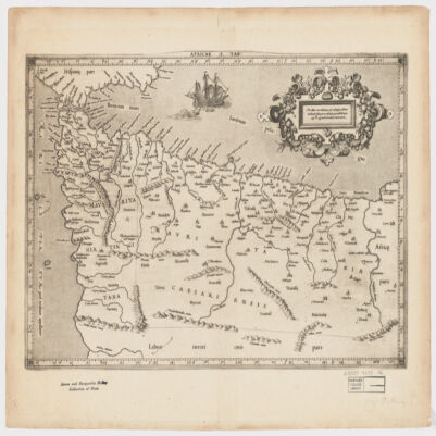
1. A generall mapp of the Coast of Barbarie, where in are the Kingdoms, and Estates of Morocco, Fez, Algiers, Tunis and Tripolialso the Kingdoms, Estates and Deserts of Barca, Egipt, Libya, Biledulgerid, Segelmesse and Darha: with the circumjacent counteries Creator: Sanson, Nicolas, 1600-1667 (المنشئ) Date: Date Issued: 1667?] Language: EnglishFrench Geographic region: Place of Production: enk, England, [LondonMoroccoTunisiaAlgeriaMauritania Extent: 1 map on 2 sheets ; 28 x 106 cm, sheets 35 x 57 cm and 35 x 59 cm.
2. A generall mapp of the Coast of Barbarie, where in are the Kingdoms, and Estates of Morocco, Fez, Algiers, Tunis and Tripolialso the Kingdoms, Estates and Deserts of Barca, Egipt, Libya, Biledulgerid, Segelmesse and Darha: with the circumjacent counteries Creator: Sanson, Nicolas, 1600-1667 (المنشئ) Date: Date Issued: 1667?] Language: EnglishFrench Geographic region: Place of Production: enk, England, [LondonMoroccoTunisiaAlgeriaMauritania Extent: 1 map on 2 sheets ; 28 x 106 cm, sheets 35 x 57 cm and 35 x 59 cm.
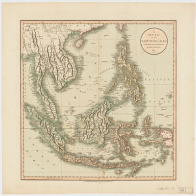
3. A new map of the East India Islesfrom the latest authorities Creator: Cary, John, approximately 1754-1835 (المنشئ) Date: Date Issued: Dec. 21, 1801 Language: English Geographic region: Place of Production: enk, England, LondonSoutheast AsiaEast IndiesIndonesiaMalay PeninsulaIndochinaPhilippines Extent: 1 map : hand col. ; 44 x 50 cm.
4. Africa with expedition routes, 1884 (Raster Image) Date: 200906 Geographic region: Africa103.12254157.594282-50.263329-73.867930
5. Africa, 1611 or 1612 (Raster Image) Date: 201204 Geographic region: AfricaMiddle EastEurope87.69118444.063898-44.943919-57.577607
6. Africa, 1700 (Raster Image) Date: 201202 Geographic region: Africa136.26490853.059878-47.801774-83.671687
7. Africa, 1730-1740 (Raster Image) Date: 201202 Geographic region: Africa87.87828149.440254-47.173313-56.184308
8. Africa, 1785 (Image 2 of 2) (Raster Image) Date: 201202 Geographic region: Africa129.30122453.016479-53.6349089.414992
9. Africa, 1795 (Raster Image) Date: 201202 Geographic region: Africa143.95762754.662494-51.894121-106.473090
10. Africa, 1797 (Raster Image) Date: 201201 Geographic region: Africa133.67160254.465561-53.071567-94.130562
11. Africa, 1800 (Raster Image) Date: 200905 Geographic region: Africa86.28407445.041388-45.849318-71.450052
12. Africa, 1805 (Raster Image) Date: 201202 Geographic region: Africa113.18103950.051365-43.455261-73.270698
13. Africa, 1815 (Raster Image) Date: 201202 Geographic region: Africa75.38448942.475973-39.724793-39.673843
14. Africa, 1834 (Raster Image) Date: 201202 Geographic region: Africa82.86500951.679764-51.621508-45.965406
15. Africa, 1890 (Raster Image) Date: 200905 Geographic region: Africa155.72943271.330211-45.438705-126.032625
16. Africa, Catholic Missions and Colonial Possessions, 1889 (Raster Image) Date: 200906 Geographic region: Africa98.68647849.591244-47.251107-60.109053
17. Africa, ca. 1680-1689 (Raster Image) Date: 201202 Geographic region: Africa116.36916252.713700-49.459512-86.118662
18. Africa, ca. 1725 (Raster Image) Date: 201204 Geographic region: AfricaMiddle EastEurope168.83259062.467856-63.513477-123.381192
19. Africae I Tab Creator: Mercator, Gerhard, 1512-1594 (المنشئ) Date: Date Issued: 1619?] Language: Latin Geographic region: Place of Production: xx, No place, unknown, or undetermined, [S.lAfrica, North Extent: 1 map ; 31 x 45 cm.
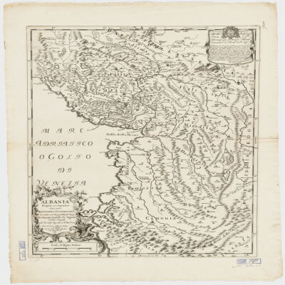
20. Albania Propria ouero Superiore detta anche Macedonia Occidentale Creator: Cantelli da Vignola, Giacomo, 1643-1719 (المنشئ) Date: Date Issued: 1689 Language: Italian Geographic region: Place of Production: it, Italy, RomaAlbania Extent: 1 map : 52 x 42 cm.