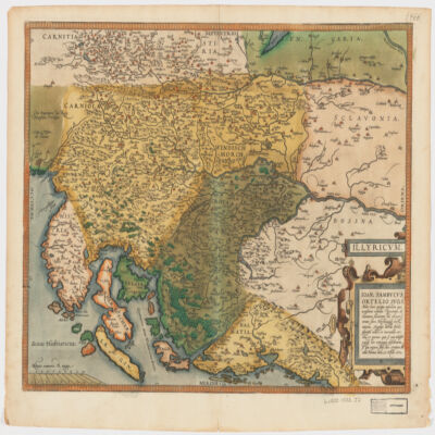
1. Illyricvm Creator: Zsámboki, János, 1531-1584 (المنشئ) Date: Date Issued: Oct. 25, 1572 Language: Latin Geographic region: Place of Production: au, Austria, ViennæBalkan PeninsulaSloveniaCroatiaBosnia and Herzegovina Extent: 1 map : hand col. ; 36 x 46 cm.
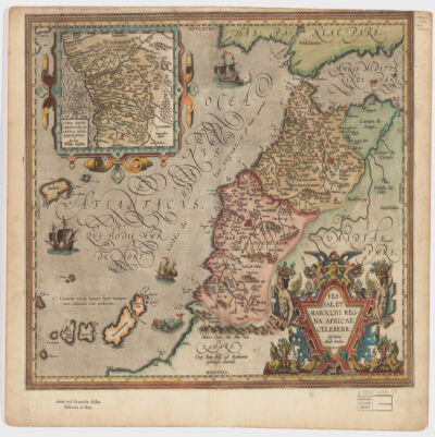
2. Fessae, et Marocchi Regna Africae celeberr Creator: Ortelius, Abraham, 1527-1598 (المنشئ) Date: Date Issued: 1595 Language: Latin Geographic region: Place of Production: be, Belgium, [Antwerp]MoroccoGibraltar, Strait ofCanary Islands Extent: 1 map : hand col. ; 37 x 48 cm.
3. Africa, 1611 or 1612 (Raster Image) Date: 201204 Geographic region: AfricaMiddle EastEurope87.69118444.063898-44.943919-57.577607
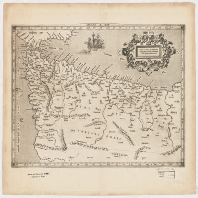
4. Africae I Tab Creator: Mercator, Gerhard, 1512-1594 (المنشئ) Date: Date Issued: 1619?] Language: Latin Geographic region: Place of Production: xx, No place, unknown, or undetermined, [S.lAfrica, North Extent: 1 map ; 31 x 45 cm.
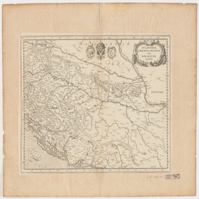
5. Sclavonia, Croatia, Bosnia cum Dalmatiæ parte Creator: Mercator, Gerhard, 1512-1594 (المنشئ) Date: Date Issued: 1630?] Language: Latin Geographic region: Place of Production: ne, Netherlands, [AmsterdamBalkan PeninsulaCroatiaBosnia and HerzegovinaSerbia Extent: 1 map ; 34 x 44 cm.
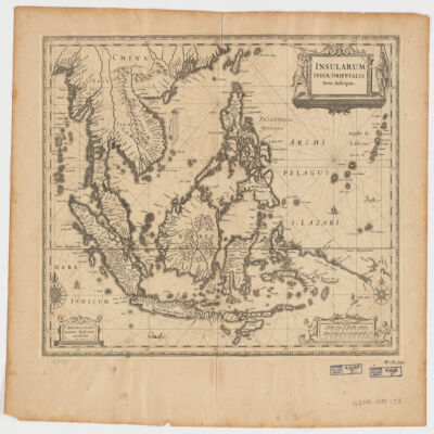
6. Insularum Indiae Orientalisnova descriptio Creator: Jansson, Jan, 1588-1664 (المنشئ) Date: Date Issued: [1650?] Language: Latin Geographic region: Place of Production: ne, Netherlands, AmstelodamiSoutheast AsiaEast Indies Extent: 1 map ; 37 x 48 cm.
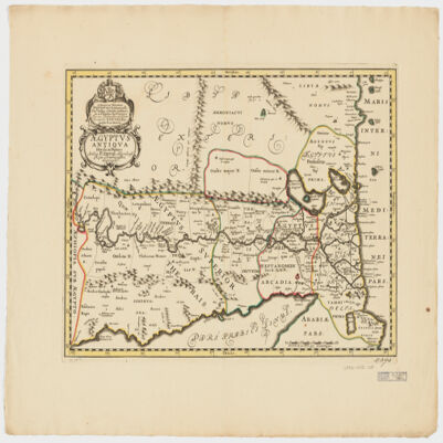
7. Ægyptus antiqua divisa in Nomos Creator: Duval, P. (Pierre), 1619-1682 (Creator) Date: Date Issued: 1652?] Language: LatinFrench Geographic region: Place of Production: ne, Netherlands, [AmsterdamEgypt Extent: 1 map : hand col. ; 35 x 50 cm.
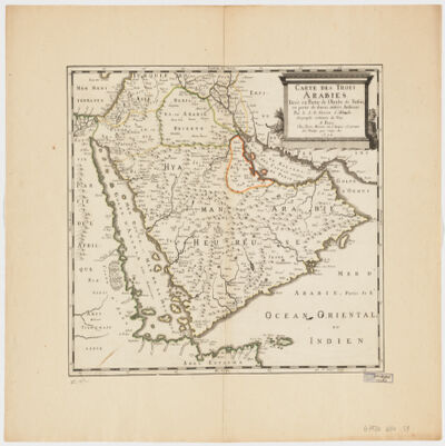
8. Carte des trois Arabiestirée en partie de l'Arabe de Nubie, en partie de diuers autres autheurs Creator: Sanson, Nicolas, 1600-1667 (المنشئ) Date: Date Issued: 1654 Language: French Geographic region: Place of Production: fr, France, ParisArabian Peninsula Extent: 1 map : hand col. ; 39 x 47 cm.
9. World Map, 1654 (Raster Image) Date: 201404 Geographic region: EarthNorthern HemisphereSouthern HemisphereEastern HemisphereWestern HemisphereAfricaAsiaAustraliaEuropeNorth AmericaSouth AmericaArctic regions18090-90-180
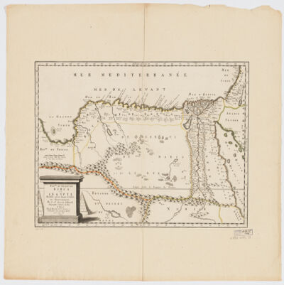
10. Royme., et désert de Barca et l'Égypte divisée en ses douze Cassifs, ou Gouvernemens Creator: Sanson, Nicolas, 1600-1667 (المنشئ) Date: Date Issued: 1655 Language: French Geographic region: Place of Production: fr, France, ParisEgyptLibya Extent: 1 map : hand col. ; 32 x 50 cm.
11. Ægypti recentior descriptioÆgyptis & Turcis Elchibith, Arabibus Mesre & Misri, Hebræis Mitsraim Date: Date Issued: 1659?] Language: LatinHebrewArabic Geographic region: Place of Production: ne, Netherlands, [AmstelodamiEgyptNile River Valley Extent: 1 map ; 39 x 50 cm.
12. A generall mapp of the Coast of Barbarie, where in are the Kingdoms, and Estates of Morocco, Fez, Algiers, Tunis and Tripolialso the Kingdoms, Estates and Deserts of Barca, Egipt, Libya, Biledulgerid, Segelmesse and Darha: with the circumjacent counteries Creator: Sanson, Nicolas, 1600-1667 (المنشئ) Date: Date Issued: 1667?] Language: EnglishFrench Geographic region: Place of Production: enk, England, [LondonMoroccoTunisiaAlgeriaMauritania Extent: 1 map on 2 sheets ; 28 x 106 cm, sheets 35 x 57 cm and 35 x 59 cm.
13. A generall mapp of the Coast of Barbarie, where in are the Kingdoms, and Estates of Morocco, Fez, Algiers, Tunis and Tripolialso the Kingdoms, Estates and Deserts of Barca, Egipt, Libya, Biledulgerid, Segelmesse and Darha: with the circumjacent counteries Creator: Sanson, Nicolas, 1600-1667 (المنشئ) Date: Date Issued: 1667?] Language: EnglishFrench Geographic region: Place of Production: enk, England, [LondonMoroccoTunisiaAlgeriaMauritania Extent: 1 map on 2 sheets ; 28 x 106 cm, sheets 35 x 57 cm and 35 x 59 cm.
14. Africa, ca. 1680-1689 (Raster Image) Date: 201202 Geographic region: Africa116.36916252.713700-49.459512-86.118662
15. Delineatio regionis Bassora cum pagis fluminibus et insulis, quæ christiani sancti Ioannis incolunt Creator: Dapper, Olfert, 1635 or 1636-1689 (المنشئ) Date: Date Issued: 1680?] Language: Latin Geographic region: Place of Production: ne, Netherlands, [AmsterdamIraqBaṣrah Region (Iraq) Extent: 1 map : hand col. ; 29 x 36 cm.
16. Albania Propria ouero Superiore detta anche Macedonia Occidentale Creator: Cantelli da Vignola, Giacomo, 1643-1719 (المنشئ) Date: Date Issued: 1689 Language: Italian Geographic region: Place of Production: it, Italy, RomaAlbania Extent: 1 map : 52 x 42 cm.
17. Indian Ocean Region, ca. 1690 (Raster Image) Date: 201110 Geographic region: AfghanistanAlgeriaAngolaArmeniaAustraliaAzerbaijanBahrainBangladeshBhutanBotswanaBritish Indian Ocean TerritoryBruneiBurmaBurundiCambodiaCameroonCentral Africian RepublicChadChinaChristmas IslandCocos (Keeling) IslandsComorosCongo, Democratic Republic of theCongo, Republic of theDjiboutiEgyptEritreaEthiopiaGabonGlorioso IslandsGuamIndiaIndonesiaIranIraqIsraelJapanJordanJuan de Nova IslandKazakhstanKenyaKuwaitKyrgyzstanLaosLesothoLibyaMadagascarMalawiMalaysiaMaldivesMauritiusMayotteMozambiqueNamibiaNepalNigerNigeriaNorth KoreaNorthern Mariana IslandsOmanPakistanPalauPapua New GuineaPhilippinesQatarReunionRwandaSaudi ArabiaSeychellesSingaporeSomaliaSouth AfricaSouth KoreaSri LankaSudanSwazilandSyriaTajikistanTanzaniaThailandTimor-LesteTurkeyTurkmenistanUgandaUnited Arab EmiratesUzbekistanVietnamYemenZambiaZimbabweIndian OceanAsiaSouth AsiaSoutheast AsiaAfrica, East177.31452253.283629-65.180727-13.682351
18. Estats de l'Empire du grand Seigneur des Turcs en Europe, en Asie, et en Afriquedivisé en tous ses Beglerbeglicz ou Gouvernements; où sont aussi remarqués les Estats qui luy sont Tributaires Creator: Jaillot, Alexis Hubert, 1632?-1712 (المنشئ) Date: Date Issued: 1696 Language: Latin Geographic region: Place of Production: fr, France, ParisTurkeyMiddle EastAfrica, NorthEurope, SouthernNorth AfricaSouthern Europe Time period: Ottoman Empire, 1288-1918 Extent: 1 map : hand colored ; 44 x 60 cm
19. Africa, 1700 (Raster Image) Date: 201202 Geographic region: Africa136.26490853.059878-47.801774-83.671687
20. Europe & Mediterranean Sea Region, 1705 (Image 2 of 2) (Raster Image) Date: 201109 Geographic region: Mediterranean SeaBlack SeaAlbaniaArmeniaAzerbaijanBosnia and HerzegovinaBulgariaCroatiaCyprusEgyptGaza StripGeorgiaGreeceHungaryIsraelItalyJordanKazakhstanLebanonLibyaMacedoniaMoldovaMontenegroPolandRomaniaRussiaSaudi ArabiaSerbiaSlovakiaSyriaTurkeyUkraineWest BankEuropeAfrica, NorthMiddle East59.63941753.88769019.1023876.174040 Extent: 2 images
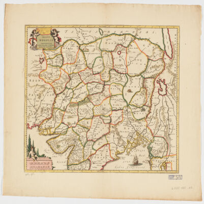
21. Magni Mogolis Imperium de novo correctum et divisum Creator: Wit, Frederik de. (المنشئ) Date: Date Issued: [1707?] Language: Latin Geographic region: Place of Production: ne, Netherlands, AmstelodamiMogul EmpireSouth AsiaAsia, Central Extent: 1 map : hand col. 40 x 50 cm.
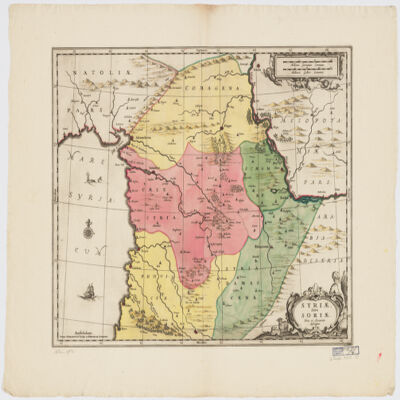
22. Syriæ Sive Soriænova et accurata descriptio Date: Date Issued: [1708?] Language: Latin Geographic region: Place of Production: ne, Netherlands, AmstelodamiSyriaLebanon Extent: 1 map : hand col. ; 41 x 49 cm.
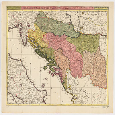
23. Dalmatia, Sclavonia, Croatia, Bosnia, Servia, et Istriadistributa in singulares ditiones et diœceses, una cum Republica Ragusana, et circumjacentibus regionibus, Hungaria, Venetiis, statu ecclesiastico, Napoli et Macedonia Creator: Valck, G. (Gerard), 1651-1726 (Creator) Date: Date Issued: [1710?] Language: LatinItalian Geographic region: Place of Production: ne, Netherlands, [Amsterdam]Balkan PeninsulaAdriatic Coast (Balkan Peninsula)Adriatic Coast (Italy) Extent: 1 map : hand col. ; 45 x 57 cm.
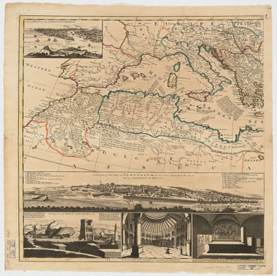
24. The Turkish Empire in Europe, Asia, and Africadividid into all its governments, together with the other territories that are tributary to it, as also the dominions of ye Emperor of Marocco [sic] according to the newest and most exact observations Creator: Moll, Herman, -1732 (المنشئ) Date: Date Issued: [1714?] Language: English Geographic region: Place of Production: enk, England, [London]TurkeyMediterranean Region Time period: Ottoman Empire, 1288-1918 Extent: 1 map on 2 sheets ; 61 x 101 cm, sheets 66 x 56 cm.