1. Decima et Vltima Evropae tabvla Contributor: Pencio, Jacopo, cactive 1486-1530 (printer.) Date: 1511] Language: Latin
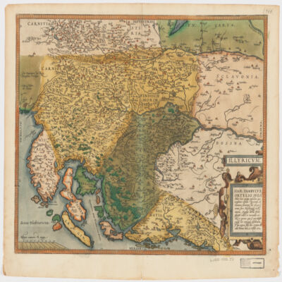
8. Illyricvm Creator: Zsámboki, János, 1531-1584 (المنشئ) Date: Date Issued: Oct. 25, 1572 Language: Latin Geographic region: Place of Production: au, Austria, ViennæBalkan PeninsulaSloveniaCroatiaBosnia and Herzegovina Extent: 1 map : hand col. ; 36 x 46 cm.
9. Questo e il uero disegno de Tunis con gran parte de lafrica tratto da uno disegno fatto al tempo che il serenissimo Imperator Carlo V lo prere lanō 1535 cō le distancie delle terre piu importante Contributor: Albertus, Gaspar (publisher.) Date: anno dm 1574 Language: Latin
11. Africae Tabvla III Contributor: Zenaro, Damiano, active 1577-1599 (publisher.) Date: 1588 Language: Latin
12. Africae Tabvla V Contributor: Zenaro, Damiano, active 1577-1599 (publisher.) Date: 1588 Language: Latin
13. Algerii Sarace norum urbis forttif fimae, in Numidia Africa Provincia Structae iuxta Balearicos fluctus Maeiterranei aequoris Hispaniam contra . . . Contributor: Braun & Hogenberg Date: 1588
14. Algerii Sarace norum vrbis fortissimae, in Numidia Africae Prouincia Structae iuxta Balearicos fluctus Maediterranei aequoris Hispaniam contra . . . Contributor: Braun & Hogenberg Date: 1588
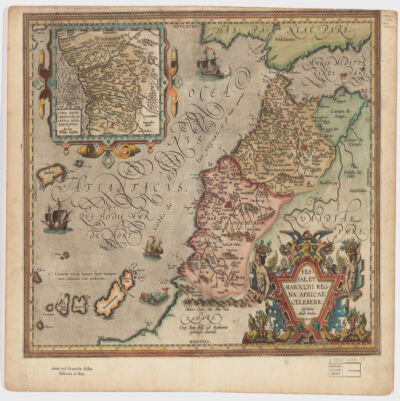
16. Fessae, et Marocchi Regna Africae celeberr Creator: Ortelius, Abraham, 1527-1598 (المنشئ) Date: Date Issued: 1595 Language: Latin Geographic region: Place of Production: be, Belgium, [Antwerp]MoroccoGibraltar, Strait ofCanary Islands Extent: 1 map : hand col. ; 37 x 48 cm.
18. Africa, 1611 or 1612 (Raster Image) Date: 201204 Geographic region: AfricaMiddle EastEurope87.69118444.063898-44.943919-57.577607
20. Africae I Tab Creator: Mercator, Gerhard, 1512-1594 (المنشئ) Date: Date Issued: 1619?] Language: Latin Geographic region: Place of Production: xx, No place, unknown, or undetermined, [S.lAfrica, North Extent: 1 map ; 31 x 45 cm.
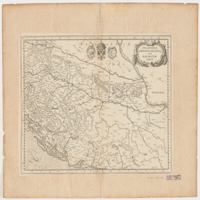
22. Sclavonia, Croatia, Bosnia cum Dalmatiæ parte Creator: Mercator, Gerhard, 1512-1594 (المنشئ) Date: Date Issued: 1630?] Language: Latin Geographic region: Place of Production: ne, Netherlands, [AmsterdamBalkan PeninsulaCroatiaBosnia and HerzegovinaSerbia Extent: 1 map ; 34 x 44 cm.
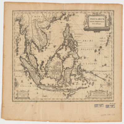
23. Insularum Indiae Orientalisnova descriptio Creator: Jansson, Jan, 1588-1664 (المنشئ) Date: Date Issued: [1650?] Language: Latin Geographic region: Place of Production: ne, Netherlands, AmstelodamiSoutheast AsiaEast Indies Extent: 1 map ; 37 x 48 cm.
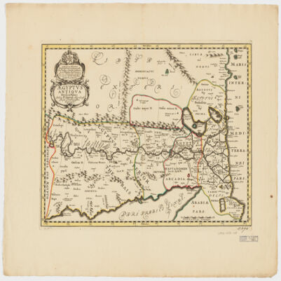
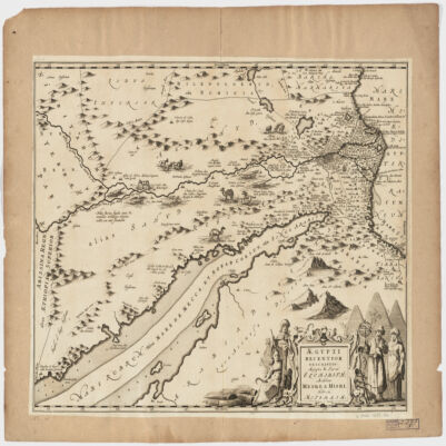
24. Ægyptus antiqua divisa in Nomos Creator: Duval, P. (Pierre), 1619-1682 (Creator) Date: Date Issued: 1652?] Language: LatinFrench Geographic region: Place of Production: ne, Netherlands, [AmsterdamEgypt Extent: 1 map : hand col. ; 35 x 50 cm.
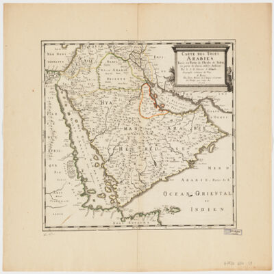
25. Carte des trois Arabiestirée en partie de l'Arabe de Nubie, en partie de diuers autres autheurs Creator: Sanson, Nicolas, 1600-1667 (المنشئ) Date: Date Issued: 1654 Language: French Geographic region: Place of Production: fr, France, ParisArabian Peninsula Extent: 1 map : hand col. ; 39 x 47 cm.
26. World Map, 1654 (Raster Image) Date: 201404 Geographic region: EarthNorthern HemisphereSouthern HemisphereEastern HemisphereWestern HemisphereAfricaAsiaAustraliaEuropeNorth AmericaSouth AmericaArctic regions18090-90-180
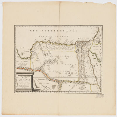
27. Royme., et désert de Barca et l'Égypte divisée en ses douze Cassifs, ou Gouvernemens Creator: Sanson, Nicolas, 1600-1667 (المنشئ) Date: Date Issued: 1655 Language: French Geographic region: Place of Production: fr, France, ParisEgyptLibya Extent: 1 map : hand col. ; 32 x 50 cm.
28. Partie de Barbarie, ou est le Royaume d'Alger Contributor: L'Huilier, Jan. (contributor) Date: 1656
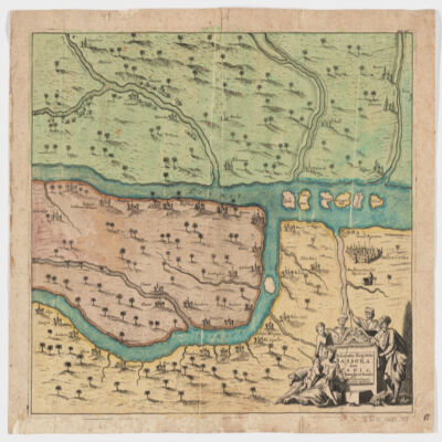
29. Ægypti recentior descriptioÆgyptis & Turcis Elchibith, Arabibus Mesre & Misri, Hebræis Mitsraim Date: Date Issued: 1659?] Language: LatinHebrewArabic Geographic region: Place of Production: ne, Netherlands, [AmstelodamiEgyptNile River Valley Extent: 1 map ; 39 x 50 cm.
30. A generall mapp of the Coast of Barbarie, where in are the Kingdoms, and Estates of Morocco, Fez, Algiers, Tunis and Tripolialso the Kingdoms, Estates and Deserts of Barca, Egipt, Libya, Biledulgerid, Segelmesse and Darha: with the circumjacent counteries Creator: Sanson, Nicolas, 1600-1667 (المنشئ) Date: Date Issued: 1667?] Language: EnglishFrench Geographic region: Place of Production: enk, England, [LondonMoroccoTunisiaAlgeriaMauritania Extent: 1 map on 2 sheets ; 28 x 106 cm, sheets 35 x 57 cm and 35 x 59 cm.
31. A generall mapp of the Coast of Barbarie, where in are the Kingdoms, and Estates of Morocco, Fez, Algiers, Tunis and Tripolialso the Kingdoms, Estates and Deserts of Barca, Egipt, Libya, Biledulgerid, Segelmesse and Darha: with the circumjacent counteries Creator: Sanson, Nicolas, 1600-1667 (المنشئ) Date: Date Issued: 1667?] Language: EnglishFrench Geographic region: Place of Production: enk, England, [LondonMoroccoTunisiaAlgeriaMauritania Extent: 1 map on 2 sheets ; 28 x 106 cm, sheets 35 x 57 cm and 35 x 59 cm.
32. Africa, ca. 1680-1689 (Raster Image) Date: 201202 Geographic region: Africa116.36916252.713700-49.459512-86.118662
33. Delineatio regionis Bassora cum pagis fluminibus et insulis, quæ christiani sancti Ioannis incolunt Creator: Dapper, Olfert, 1635 or 1636-1689 (المنشئ) Date: Date Issued: 1680?] Language: Latin Geographic region: Place of Production: ne, Netherlands, [AmsterdamIraqBaṣrah Region (Iraq) Extent: 1 map : hand col. ; 29 x 36 cm.
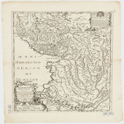
34. Albania Propria ouero Superiore detta anche Macedonia Occidentale Creator: Cantelli da Vignola, Giacomo, 1643-1719 (المنشئ) Date: Date Issued: 1689 Language: Italian Geographic region: Place of Production: it, Italy, RomaAlbania Extent: 1 map : 52 x 42 cm.
35. Indian Ocean Region, ca. 1690 (Raster Image) Date: 201110 Geographic region: AfghanistanAlgeriaAngolaArmeniaAustraliaAzerbaijanBahrainBangladeshBhutanBotswanaBritish Indian Ocean TerritoryBruneiBurmaBurundiCambodiaCameroonCentral Africian RepublicChadChinaChristmas IslandCocos (Keeling) IslandsComorosCongo, Democratic Republic of theCongo, Republic of theDjiboutiEgyptEritreaEthiopiaGabonGlorioso IslandsGuamIndiaIndonesiaIranIraqIsraelJapanJordanJuan de Nova IslandKazakhstanKenyaKuwaitKyrgyzstanLaosLesothoLibyaMadagascarMalawiMalaysiaMaldivesMauritiusMayotteMozambiqueNamibiaNepalNigerNigeriaNorth KoreaNorthern Mariana IslandsOmanPakistanPalauPapua New GuineaPhilippinesQatarReunionRwandaSaudi ArabiaSeychellesSingaporeSomaliaSouth AfricaSouth KoreaSri LankaSudanSwazilandSyriaTajikistanTanzaniaThailandTimor-LesteTurkeyTurkmenistanUgandaUnited Arab EmiratesUzbekistanVietnamYemenZambiaZimbabweIndian OceanAsiaSouth AsiaSoutheast AsiaAfrica, East177.31452253.283629-65.180727-13.682351
36. States and kingdoms of Fez Moroc, Darha and Segelmesse. Contributor: Sanson, Guillaume (1633-1703) (author) Date: 1695
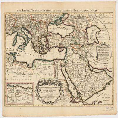
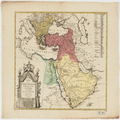
37. Estats de l'Empire du grand Seigneur des Turcs en Europe, en Asie, et en Afriquedivisé en tous ses Beglerbeglicz ou Gouvernements; où sont aussi remarqués les Estats qui luy sont Tributaires Creator: Jaillot, Alexis Hubert, 1632?-1712 (المنشئ) Date: Date Issued: 1696 Language: Latin Geographic region: Place of Production: fr, France, ParisTurkeyMiddle EastAfrica, NorthEurope, SouthernNorth AfricaSouthern Europe Time period: Ottoman Empire, 1288-1918 Extent: 1 map : hand colored ; 44 x 60 cm
38. Africa, 1700 (Raster Image) Date: 201202 Geographic region: Africa136.26490853.059878-47.801774-83.671687
39. Part of Barbary or the Kingdom of Algiers. Contributor: Sanson, Guillaume (1633-1703) (author) Date: 1704
40. Europe & Mediterranean Sea Region, 1705 (Image 2 of 2) (Raster Image) Date: 201109 Geographic region: Mediterranean SeaBlack SeaAlbaniaArmeniaAzerbaijanBosnia and HerzegovinaBulgariaCroatiaCyprusEgyptGaza StripGeorgiaGreeceHungaryIsraelItalyJordanKazakhstanLebanonLibyaMacedoniaMoldovaMontenegroPolandRomaniaRussiaSaudi ArabiaSerbiaSlovakiaSyriaTurkeyUkraineWest BankEuropeAfrica, NorthMiddle East59.63941753.88769019.1023876.174040 Extent: 2 images
41. Magni Mogolis Imperium de novo correctum et divisum Creator: Wit, Frederik de. (المنشئ) Date: Date Issued: [1707?] Language: Latin Geographic region: Place of Production: ne, Netherlands, AmstelodamiMogul EmpireSouth AsiaAsia, Central Extent: 1 map : hand col. 40 x 50 cm.
42. Syriæ Sive Soriænova et accurata descriptio Date: Date Issued: [1708?] Language: Latin Geographic region: Place of Production: ne, Netherlands, AmstelodamiSyriaLebanon Extent: 1 map : hand col. ; 41 x 49 cm.
43. Dalmatia, Sclavonia, Croatia, Bosnia, Servia, et Istriadistributa in singulares ditiones et diœceses, una cum Republica Ragusana, et circumjacentibus regionibus, Hungaria, Venetiis, statu ecclesiastico, Napoli et Macedonia Creator: Valck, G. (Gerard), 1651-1726 (Creator) Date: Date Issued: [1710?] Language: LatinItalian Geographic region: Place of Production: ne, Netherlands, [Amsterdam]Balkan PeninsulaAdriatic Coast (Balkan Peninsula)Adriatic Coast (Italy) Extent: 1 map : hand col. ; 45 x 57 cm.
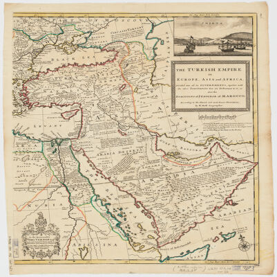
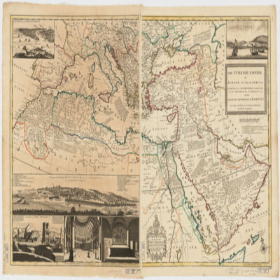
44. The Turkish Empire in Europe, Asia, and Africadividid into all its governments, together with the other territories that are tributary to it, as also the dominions of ye Emperor of Marocco [sic] according to the newest and most exact observations Creator: Moll, Herman, -1732 (المنشئ) Date: Date Issued: [1714?] Language: English Geographic region: Place of Production: enk, England, [London]TurkeyMediterranean Region Time period: Ottoman Empire, 1288-1918 Extent: 1 map on 2 sheets ; 61 x 101 cm, sheets 66 x 56 cm.
45. The Turkish Empire in Europe, Asia, and Africadividid into all its governments, together with the other territories that are tributary to it, as also the dominions of ye Emperor of Marocco [sic] according to the newest and most exact observations Creator: Moll, Herman, -1732 (المنشئ) Date: Date Issued: [1714?] Language: English Geographic region: Place of Production: enk, England, [London]TurkeyMediterranean Region Time period: Ottoman Empire, 1288-1918 Extent: 1 map on 2 sheets ; 61 x 101 cm, sheets 66 x 56 cm.
46. The Turkish Empire in Europe, Asia, and Africadividid into all its governments, together with the other territories that are tributary to it, as also the dominions of ye Emperor of Marocco [sic] according to the newest and most exact observations Creator: Moll, Herman, -1732 (المنشئ) Date: Date Issued: [1714?] Language: English Geographic region: Place of Production: enk, England, [London]TurkeyMediterranean Region Time period: Ottoman Empire, 1288-1918 Extent: 1 map on 2 sheets ; 61 x 101 cm, sheets 66 x 56 cm.
47. Chart of the Strait of Babellmandell made by John Friend Against ye East India hous in leaden hall Street London An.o Dn.o 1714 Date: 1714/1714 Language: English Geographic region: Babelmandel Extent: 1 map
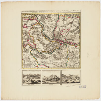
48. Nieuwe en Accurate Caart van de Omleggende Lande van Belgradoals mede des selfs Belegeringh, ende Marse der Keyserlycke Armee, Ao. 1717 Creator: Ottens, Joachim, 1663-1719 (المنشئ) Date: Date Issued: [1717?] Language: DutchLatin Geographic region: Place of Production: ne, Netherlands, AmsterdamSerbiaBelgrade Region (Serbia)Petrovaradin (Serbia)Belgrade (Serbia)Timiṣoara (Romania) Time period: Siege, 1717 Extent: 1 map : hand col. ; 31 x 38 cm.
49. De Stad Haven En Mouillie Van Algiers Neven Desselfs Kasteelen Contributor: Van Keulen Date: 1720
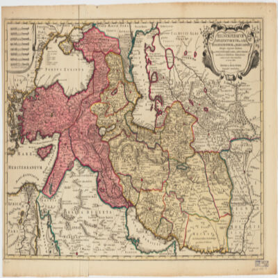
50. Imperium Turcicum per Europam, Asiam Et Africam se extendens et secundum Beglerbegatus sive Praefecturas accurate distinctum Creator: Seutter, Matthaeus, 1678-1756 (المنشئ) Date: Date Issued: [1720?] Language: GermanLatin Geographic region: Place of Production: gw, Germany, AugspurgTurkeyIslamic countries Extent: 1 map : hand col. ; 27 x 25 cm., on sheet 61 x 52 cm.
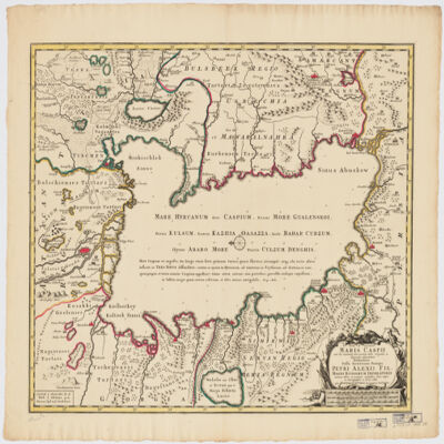
51. Nova ac verissima Maris Caspii ante hac maximam fere partem nobis incogniti ac regionum adjacentium delineatiojussu invictissimi principis Petri Alexii fil. magni Russorum imperatoris Creator: Ottens, R. (Reinier), 1698-1750 (Creator) Date: Date Issued: [1720?] Language: LatinDutch Geographic region: Place of Production: ne, Netherlands, AmsterdamCaspian Sea RegionCaspian SeaCaspian Sea Coast Extent: 1 map : hand col. ; 47 x 57 cm.
52. Africa, ca. 1725 (Raster Image) Date: 201204 Geographic region: AfricaMiddle EastEurope168.83259062.467856-63.513477-123.381192
53. Magnae Tartariae, magni Mogolis Imperii, Iaponiae et Chinaenova descriptio ex tabula Creator: Wit, Frederik de. (المنشئ) Date: Date Issued: [ca. 1725?] Language: Latin Geographic region: Place of Production: ne, Netherlands, AmstelodamiAsia Extent: 1 map : hand col. ; 41 x 52 cm.
54. World Map, 1725 (Image 2 of 2) (Raster Image) Date: 200910 Geographic region: EarthEastern HemisphereAfricaAsiaAustraliaEuropeSouth AmericaArctic regions171.98918283.865163-68.289741-65.093564
55. Africa, 1730-1740 (Raster Image) Date: 201202 Geographic region: Africa87.87828149.440254-47.173313-56.184308
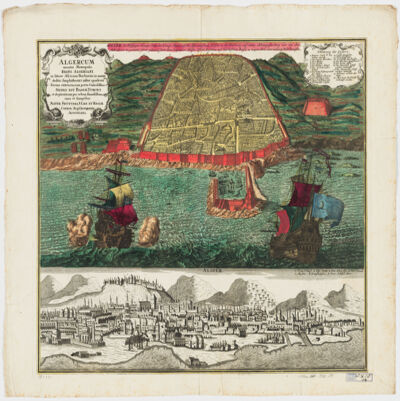
56. Algercum munita metropolis Regni Algeriani : in littore Africano Barbariæ in monte declivi Amphitheatri instar quadrata forma extructa, cum portu Commodissimo Sedes est Bassæ Turcici et ob piraticam per orbem famosissima =Algier die Befestigte Haupt-Statt des Königr. Algier, Auf die Africanischen Küsten in der Barbarey auf einem abhängigen Berg wie ein Amphiteatrum in gevierten form gebauet samt dem bequemen hasen. Ift die Residenz des Türkischen Bassa u: wegen ihrer Secrauberey Welt berussen Creator: Seutter, Matthaeus, 1678-1756 (المنشئ) Date: Date Issued: [1730?] Language: GermanLatin Geographic region: Place of Production: au, Austria, AugustaniAlgiers (Algeria) Extent: 1 view : hand col. ; 48 x 56 cm.
57. Red Sea Region, North Africa, ca. 1730 (Raster Image) Date: 201312 Geographic region: AfricaAfrica, NorthRed SeaArabian PeninsulaMediterranean SeaAlgeriaAzerbaijanBahrainCameroonCentral African RepublicChadCongoCongo Democratic Republic of theCyprusDijiboutiEgyptEritreaEthiopiaGaza StripGreeceIranIraqIsraelItalyJordanKenyaKuwaitLebanonLibyaMaltaNigerNigeriaOmanQatarSaudi ArabiaSomaliaSudanSyriaTunisiaTurkeyUgandaUnited Arab EmiratesWest BankYemen84.36247844.728074-5.683373-5.414094
58. Regnum Persicum Imperium Turcicum in Asia Russorum Provinciae ad Mare Caspiumaliaequae regiones finitimae, item Ponti Euxini, Maris Caspii, ac Sinus Persici novissimae ac fidelissimae delineationes omnia Creator: R. & J. Ottens (المنشئ) Date: Date Issued: [ca. 1730] Language: Latin Geographic region: Place of Production: ne, Netherlands, AmstelaedamMiddle EastAsiaAsia, CentralCaucasusTurkey Extent: 1 map : col. ; 48 X 83 cm.
59. Nette Aftekening Der Stad Oran &c. Gelege in Barbaryen Opgedragen aasn den Ed. Heer Cornelis Schyver Captyn ter Zee . . . 1732 Contributor: Ottens Date: 1732
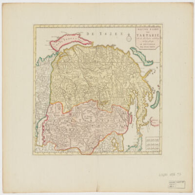
60. Nieuwe kaart van Tartarie na de alderlaaste ondekking int ligt gebragt Creator: Tirion, Isaak, 1705-1769 (المنشئ) Date: Date Issued: 1732 Language: Dutch Geographic region: Place of Production: ne, Netherlands, AmsterdamSiberia (Russia)KazakhstanMongolia Extent: 1 map : hand col. ; 27 x 33 cm.
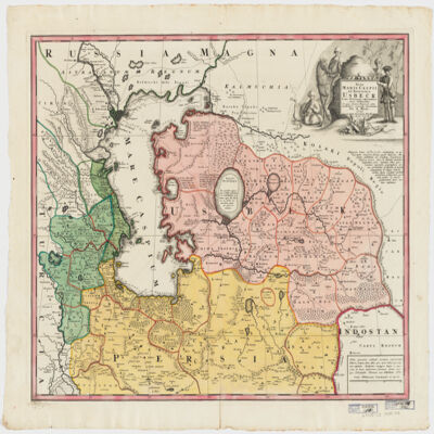
62. Nova Maris Caspii et regionis Usbeck, cum provincijs adjacentibus vera delineatio Creator: Maas, Abraham. (المنشئ) Date: Date Issued: 1735 Language: Latin Geographic region: Place of Production: gw, Germany, [Nuremberg]UzbekistanIranCaspian Sea RegionAsia, Central Extent: 1 map : hand col. ; 47 x 57 cm.
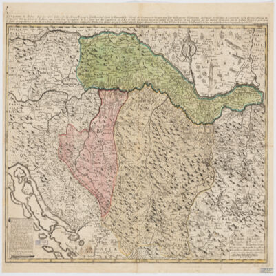
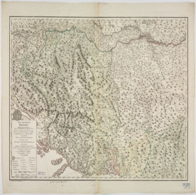
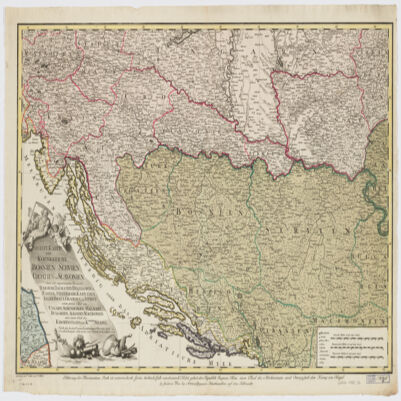
63. Le Royaume de Bosnie, dans son entier, dédié a son Excellence Monseignr. le feld Maréchal Comte de Khewenhüller Colonel d'un Régiment de Dragon Vice Roy d'Esclavonie, du Duché de Syrmie et Gouverneur de la Forteresse d'Essegg etc Creator: Briffaut, Étienne. (المنشئ) Date: Date Issued: 1740 Language: FrenchLatin Geographic region: Place of Production: fr, France, VienneBosnia and HerzegovinaCroatia Extent: 1 map : hand col. ; 60 x 90 cm.
64. [Algeria Sea Chart] The Seat Coast of Barbary From Cape de Tenes to Cape de Rosa Contributor: Mount & Page Date: 1740
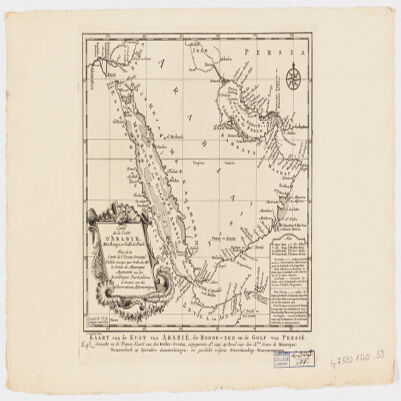
65. Carte de la coste d'Arabie, Mer Rouge et Golfe de Persetirée de la Carte de l'Océan Oriental publiée en 1740 par Ordre de Mgr le Comte de Maurepas augmentée sur des remarques particulières et dressée sur des observations astronomiques = Kaart van de Kust van Arabië, de Roode-Zee en de Gulf van Persië Gemaakt na de Fransse-Kaart van den Ooster-Ocean uitgegeven A. 1740 op Bevel van den Hre Grave de Maurepas Vermeederd op byzondere Aanmerkingen, en geschikt volgens Sterrekundige-Waarnemingen Creator: Schley, Jacobus van der, 1715-1779 (المنشئ) Date: Date Issued: between 1747 and 1767] Language: FrenchDutch Geographic region: Place of Production: ne, Netherlands, [HagueArabian Peninsula Extent: 1 map ; 24 x 21 cm.
66. A map of Ancient Aegypt from Celarius. Creator: Cellarius, Andreas. Date: ca. 1750 Language: English Geographic region: Egypt; Africa
67. Aegypti Delta et Nili Ostia Creator: Cellarius, Christoph 1638-1707 Date: ca. 1750 Language: Latin Geographic region: Egypt; Africa
68. Theatrum historicum ad annum Christi quadrigentesimũin quo tũ Imperii Romani tũ Barbarorum circumincolentium status ob oculos ponitur pars orientalis Creator: L'Isle, Guillaume de, 1675-1726 (المنشئ) Date: Date Issued: [between 1759 and 1799] Language: Latin Geographic region: Place of Production: ne, Netherlands, AmstelodamiEastern Hemisphere Extent: 1 map : hand col. ; 47 x 60 cm.
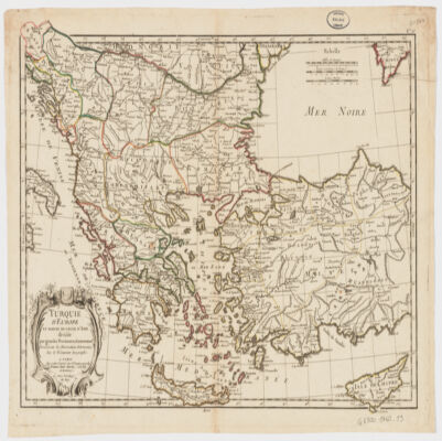
69. Turquie d'Europe et partie de celle d'Asie divisée par grandes provinces et gouvernemts Creator: Janvier, Jean Denis (المنشئ) Date: Date Issued: [1760?] Language: French Geographic region: Place of Production: fr, France, BordeauxBalkan PeninsulaTurkeyThrace, Eastern (Turkey)
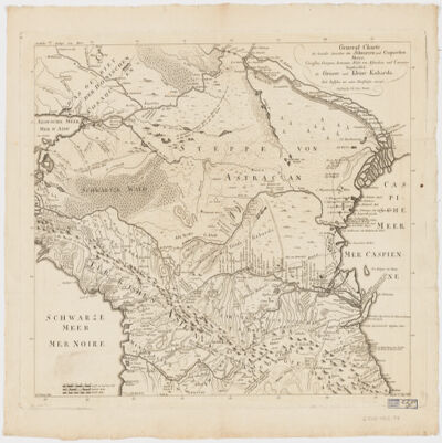
78. General Charte der Laender Zwischen dem Schwarzen und Caspischen MeereCircassien, Georgien, Armenien, Wüste von Astrachan und Caucasus hauptsoechlich die Grosse und Kleine Kabarda Creator: Treuttel, Jean-Georges, 1744-1826 (المنشئ) Date: Date Issued: [between 1765 and 1800?] Language: GermanFrench Geographic region: Place of Production: gw, Germany, StrasburgRussia (Federation)GeorgiaCaucasus, South Extent: 1 map ; 46 x 57 cm.
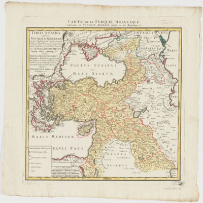
79. Turcia Asiaticaexhibens Natoliam modernam, in suos beglirbegatus divisam, itemque reliquos beglirbegatus, sive gubernationes et Prœfecturas generales, in regionibus Georgiæ, Armeniæ, Mespotamiæ, Syriæ et Arabiæ sitos, una cum Mari Nigro, Mari Azowiensi, Mari di Marmora, et Mari Ægeo, atque adiacentibus Insulis : C. P. S. C. M. = Carte de la Turquie asiatique contenant la Natolie moderne divisée en les beglerbeys & Creator: Homann Erben (Firm) (Creator) Date: Date Issued: 1771 Language: LatinFrench Geographic region: Place of Production: gw, Germany, NorimbergæMiddle EastTurkey Extent: 1 map : hand col. ; 44 x 51 cm.
80. Mare Rubrum seu Sinus Arabicusad observationes maximam partem ab Auctore annis MDCCLXII et MDCCLXIII institutas Creator: Niebuhr, C. (المنشئ) Date: Date Issued: 1772 Language: Latin Geographic region: Place of Production: xx, No place, unknown, or undetermined, HafniaeRed Sea RegionRed Sea Coast (Saudi Arabia)Red Sea Coast (Egypt)Red Sea Coast (Yemen)Red Sea Coast (Jordan) Extent: 1 map ; 78 x 21 cm.
81. Oceania and Australasia, 1773 (Raster Image) Date: 200905 Geographic region: Southern HemisphereAustraliaAustralasiaOceaniaPacific Ocean180.00000047.083860-70.929153-180.000000
82. Terrae Yemen maxima Pars. seu Imperii Imami, Principatus Kaukebân, nec non ditionum Haschid U Bekîl, Nehhm, Chaulân, Abu Arîsch Et Aden Tabulaex observationibus astronomicis et hodometricis jussu et suntibus Potentissimor: Daniae Regnum Friderici V et Christiani VII institutis Creator: Niebuhr, Carsten, 1733-1815 (المنشئ) Date: Date Issued: 1774 Language: Latin Geographic region: Place of Production: gw, Germany, Aug. VindYemen (Republic) Extent: 1 map : hand col. ; 56 X 37 cm.
83. World Map, ca. 1774 (Raster Image) Date: 200910 Geographic region: EarthNorthern HemisphereSouthern HemisphereEastern HemisphereWestern HemisphereAfricaAsiaAustraliaEuropeNorth AmericaSouth AmericaArctic regions180.00000084.976331-76.321183-180.000000
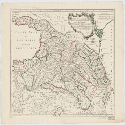
84. Carte de la Géorgie et des pays situés entre la mer Noire et la mer Caspiennedessinée en 1738 d'après les Cartes, Mémoires, Mesures et Observations des gens du Pays Creator: Santini, P. (المنشئ) Date: Date Issued: 1775 Language: FrenchGeorgian Geographic region: Place of Production: it, Italy, VeniceGeorgia (Republic)Armenia Extent: 1 map : hand col. ; 46 x 64 cm.
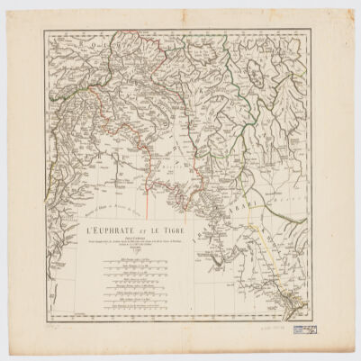
85. L' Euphrate et le Tigre Creator: Anville, Jean Baptiste Bourguignon d', 1697-1782 (المنشئ) Date: Date Issued: 1779 Language: FrenchLatin Geographic region: Place of Production: fr, France, [ParisEuphrates RiverTigris RiverIraqSyriaTurkey Extent: 1 map : hand col. ; 42 x 51 cm.
86. Africa, 1785 (Image 2 of 2) (Raster Image) Date: 201202 Geographic region: Africa129.30122453.016479-53.6349089.414992
87. 'View of Muscat, entrance of Persian Gulph' Date: 1787/1787 Language: English Geographic region: Muscat Extent: 1 view
88. Das Kœnigreich Bosnien, und die Herzegovina (Rama) samt den angrœnzenden Provinzen von Croatien, Sclavonien, Temesvar, Servien, Albanien, Ragusa, und den Venetianischen Dalmatien Creator: Schimek, Maximilian. (المنشئ) Date: Date Issued: 1788 Language: German Geographic region: Place of Production: au, Austria, WienBalkan Peninsula Extent: 1 map : hand col. ; 65 x 103 cm.
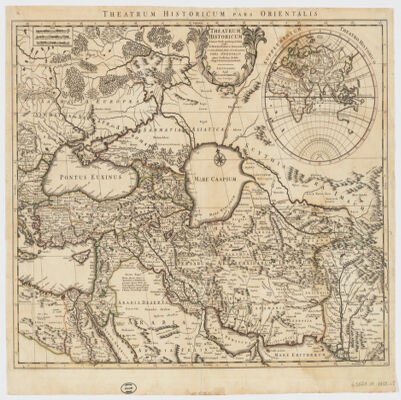
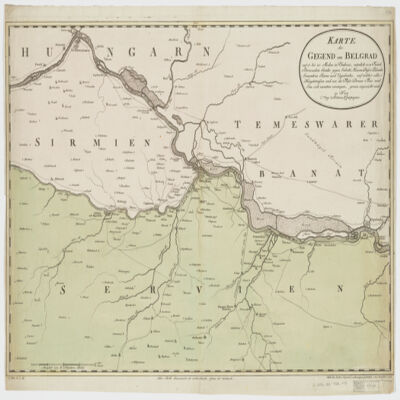
89. Karte der Gegend um Belgradauf 15 bis 20 Meilen in Umkreis, nämlich von Futak Peterwardein Semlin gegen Sabatz, Hassan Bassa Palanka Semendria Rama und Uypalanka, auf welcher alle Hauptstrassen und wie die Flüsse Donau Theis und Sau sich zusammen vereinigen, genau angezeicht sind Creator: Mansfeld. (المنشئ) Date: Date Issued: 1788 Language: German Geographic region: Place of Production: au, Austria, WienSerbiaHungary Extent: 1 map : hand col. ; 47 x 67 cm.
90. Neueste Karte der Koenigreiche Bosnien Servien Croatien und Slavoniensamt den angrænzenden Provinzen Temeswar, Dalmatien, Herzegowina, Ragusa, Steyermark, Kærthen, Krain, Friaul, Gradiska, und Istrien, einem grossen Theil von Ungarn, Siebenbürgen, Walachei, Bulgarien, Albanien, Macedonien, und einem Stück des Kirchenstaats und K. Reichs Neapel Creator: Schütz, Karl, 1745-1800 (المنشئ) Date: Date Issued: 1788 Language: German Geographic region: Place of Production: au, Austria, WienBalkan Peninsula Extent: 1 map : hand col. ; 47 x 71cm.
91. Empire de la Porte ottomane en Europe, en Asie et en Afrique avec les pays qui lui sont tributaires Creator: Lotter Brothers (Firm) (Creator) Date: Date Issued: [1790?] Language: French Geographic region: Place of Production: gw, Germany, AugsburgMiddle EastTurkeyEurope, SouthernAfrica, North Extent: 1 map : hand col. ; 47 x 55 cm.
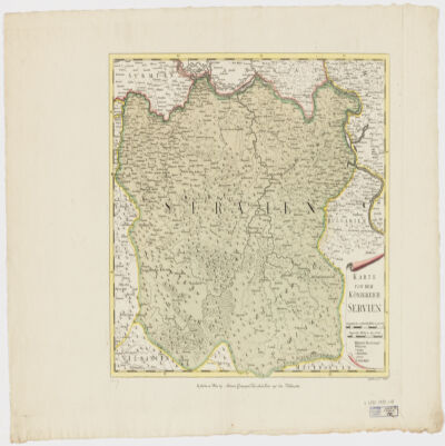
92. Karte von dem Königreich Serbien Creator: Müller, F. (المنشئ) Date: Date Issued: [1790?] Language: German Geographic region: Place of Production: au, Austria, WienSerbia Extent: 1 map : hand col. ; 36 x 43 cm.
93. Ottoman Empire, ca. 1790 (Raster Image) Date: 201001 Geographic region: AlbaniaAlgeriaArmeniaAustriaAzerbaijanBahrainBosnia & HerzegovinaBulgariaCroatiaCyprusEgyptEritreaFranceGaza StripGeorgiaGreeceHungaryIranIraqIsraelItalyJordanKazakhstanKuwaitLebanonLibyaMacedoniaMaltaMoldovaMontenegroOmanPolandQatarRomaniaRussiaSan MarinoSaudi ArabiaSerbiaSlovakiaSloveniaSomaliaSudanSyriaTunisiaTurkeyTurkmenistanUkraineUnited Arab EmiratesUzbekistanVatican CityWest BankYemen89.99419957.5464463.534051-14.597445
94. 'A New Map of the Empire of Persia from Monsr. D'Anville, First Geographer to the most Christian King, with Several Additions and Emendations' Contributor: Laurie & Whittle, Publishers and publishing (publisher)Jean Baptiste Bourgignon d'Anville (publisher) Date: 1794/1794 Language: English Geographic region: Persia Extent: 1 map sheet
96. Africa, 1795 (Raster Image) Date: 201202 Geographic region: Africa143.95762754.662494-51.894121-106.473090