1. "Societe Royale D'AgriculturePlan General de la XVIe Exposition Agricole et Industrielle" Creator: "Societe Royale d'Agriculture" Date: 1949 Language: French Geographic region: Cairo; Egypt
2. "Voyages d'Ali Bey El Abbassi en Afrique et en Asie pendant les années 1803180418051806 et 1807." Creator: Ali Bey, 1766-1818. Date: 1814 Language: French Geographic region: North Africa; Middle East
3. Distribution of Social Agencies in Cairo Creator: American University at Cairo. Social Research Center. Date: 1956 Language: English Geographic region: Cairo; Egypt
4. Allied-Axis Position in the Near East - Autumn 1941 Creator: American University in Cairo Date: 1941 Language: English Geographic region: Egypt; North Africa
5. Palestine ancienne & moderne d'après les sources les plus authentiques Creator: Andriveau-Goujon, E. (Eugène), 1832-1897 (المنشئ) Date: Date Issued: 1876 Language: FrenchLatinArabicHebrew Geographic region: Place of Production: fr, France, ParisPalestineLebanon Extent: 1 map : col. ; 62 x 46 cm.
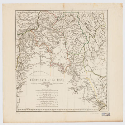
6. L' Euphrate et le Tigre Creator: Anville, Jean Baptiste Bourguignon d', 1697-1782 (المنشئ) Date: Date Issued: 1779 Language: FrenchLatin Geographic region: Place of Production: fr, France, [ParisEuphrates RiverTigris RiverIraqSyriaTurkey Extent: 1 map : hand col. ; 42 x 51 cm.
7. Egypt. Creator: Arrowsmith, John, 1790-1873 Date: ca. 1840 Language: English Geographic region: Egypt; Africa
8. View of Proposed Development - Midan Ismail Creator: Badeau, John S. Date: 1950-06-14 Language: English Geographic region: Cairo; Egypt
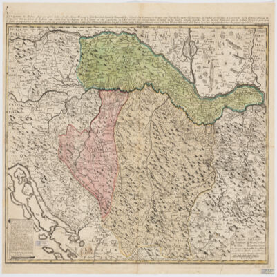
9. Le Royaume de Bosnie, dans son entier, dédié a son Excellence Monseignr. le feld Maréchal Comte de Khewenhüller Colonel d'un Régiment de Dragon Vice Roy d'Esclavonie, du Duché de Syrmie et Gouverneur de la Forteresse d'Essegg etc Creator: Briffaut, Étienne. (المنشئ) Date: Date Issued: 1740 Language: FrenchLatin Geographic region: Place of Production: fr, France, VienneBosnia and HerzegovinaCroatia Extent: 1 map : hand col. ; 60 x 90 cm.
10. Maps from "Cairo and its environs" Creator: Bénédite, Georges Aaron, 1857- Date: 1910 Language: EnglishFrench Geographic region: Cairo; Egypt
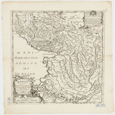
11. Albania Propria ouero Superiore detta anche Macedonia Occidentale Creator: Cantelli da Vignola, Giacomo, 1643-1719 (المنشئ) Date: Date Issued: 1689 Language: Italian Geographic region: Place of Production: it, Italy, RomaAlbania Extent: 1 map : 52 x 42 cm.
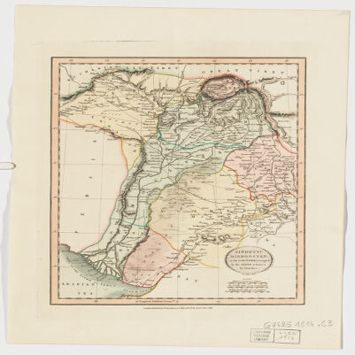
12. Sindetic Hindoostan or the countries occupied by the Sinde or Indus and its branches Creator: Cary, John, approximately 1754-1835 (المنشئ) Date: Date Issued: June 1, 1816 Language: English Geographic region: Place of Production: enk, England, LondonSouth Asia Extent: 1 map : hand col. ; 27 x 22 cm.
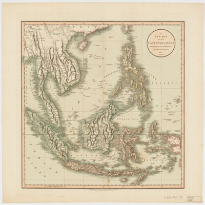
13. A new map of the East India Islesfrom the latest authorities Creator: Cary, John, approximately 1754-1835 (المنشئ) Date: Date Issued: Dec. 21, 1801 Language: English Geographic region: Place of Production: enk, England, LondonSoutheast AsiaEast IndiesIndonesiaMalay PeninsulaIndochinaPhilippines Extent: 1 map : hand col. ; 44 x 50 cm.
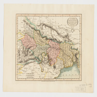
14. Gangetic Hindoostan or the countries occupied by the Ganges and the branches Creator: Cary, John, approximately 1754-1835 (المنشئ) Date: Date Issued: June 1, 1816 Language: English Geographic region: Place of Production: enk, England, LondonIndia, NortheasternBangladeshNepal Extent: 1 map : hand col. ; 22 x 27 cm.
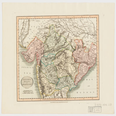
15. Central division of Hindoostan Creator: Cary, John, approximately 1754-1835 (المنشئ) Date: Date Issued: June 1, 1816 Language: English Geographic region: Place of Production: enk, England, LondonIndia Extent: 1 map : hand col. ; 22 x 27 cm.
16. A map of Ancient Aegypt from Celarius. Creator: Cellarius, Andreas. Date: ca. 1750 Language: English Geographic region: Egypt; Africa
17. Aegypti Delta et Nili Ostia Creator: Cellarius, Christoph 1638-1707 Date: ca. 1750 Language: Latin Geographic region: Egypt; Africa
18. Delineatio regionis Bassora cum pagis fluminibus et insulis, quæ christiani sancti Ioannis incolunt Creator: Dapper, Olfert, 1635 or 1636-1689 (المنشئ) Date: Date Issued: 1680?] Language: Latin Geographic region: Place of Production: ne, Netherlands, [AmsterdamIraqBaṣrah Region (Iraq) Extent: 1 map : hand col. ; 29 x 36 cm.
19. Gardens of Cairo Creator: Delchevalerie, G. Date: 1899 Language: French Geographic region: Cairo; Egypt
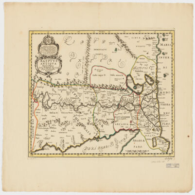
20. Ægyptus antiqua divisa in Nomos Creator: Duval, P. (Pierre), 1619-1682 (Creator) Date: Date Issued: 1652?] Language: LatinFrench Geographic region: Place of Production: ne, Netherlands, [AmsterdamEgypt Extent: 1 map : hand col. ; 35 x 50 cm.
21. Plan des Necropoles Thebaines Creator: E Baraize; Egypt. Maṣlaḥat al-Āthār Date: 1912 Language: French Geographic region: Thebes; Qinā; Egypt
22. Maps from "Tārīkh al-barīd fī Miṣr" Creator: Egypt. Maṣlaḥat al-Barīd Date: 1934 Language: ArabicFrench Geographic region: Egypt
23. Guide plan of Cairo and district. Creator: Egypt. Maṣlaḥat al-Misāḥah Date: 1932 Language: English Geographic region: Cairo; Egypt; Giza; Egypt; Heliopolis; Egypt
24. Residential map of Gezîra: (Zamâlik area). Creator: Egypt. Maṣlaḥat al-Misāḥah Date: 1937 Language: English Geographic region: Az Zamālik; Egypt
25. Cairo Muhammadan Monuments Creator: Egypt. Maṣlaḥat al-Misāḥah Date: 1948 Geographic region: Cairo; Egypt
26. Outline map of Cairo Creator: Egypt. Maṣlaḥat al-Misāḥah Date: 1947 Language: English Geographic region: Cairo; Egypt; Giza; Egypt
27. Cairo Creator: Egypt. Maṣlaḥat al-Misāḥah Date: 1930 Language: EnglishArabic Geographic region: Cairo; Egypt
28. General map of Alexandria Creator: Egypt. Maṣlaḥat al-Misāḥah Date: 1934 Language: English Geographic region: Alexandria; Egypt
29. Ramleh (El Raml) Creator: Egypt. Maṣlaḥat al-Misāḥah Date: 1938 Language: Arabic Geographic region: Alexandria; Egypt
30. El-Maadi Creator: Egypt. Maṣlaḥat al-Misāḥah Date: 1945 Language: EnglishArabic Geographic region: Maadi; Cairo; Egypt
31. Communications Map of Lower Egypt and the Fayûm Creator: Egypt. Maṣlaḥat al-Misāḥah Date: 1929 Language: English Geographic region: Nile Delta; Al Fayyūm; Egypt
32. Banha Creator: Egypt. Maṣlaḥat al-Misāḥah Date: 1945 Language: Arabic Geographic region: Banhā; Al Qalyūbīyah; Egypt
33. Alexandria Creator: Egypt. Maṣlaḥat al-Misāḥah Date: 1953 Language: Arabic Geographic region: Alexandria; Egypt
34. Luxor Creator: Egypt. Maṣlaḥat al-Misāḥah Date: 1931 Language: Arabic Geographic region: Luxor; Al Uqşur; Egypt
35. Cairo Heliopolis Creator: Egypt. Maṣlaḥat al-Misāḥah Date: 1952 Language: English Geographic region: Heliopolis; Cairo; Egypt
36. Nile main stream, between Halfa and Khartoum with the locations of the second and fourth water falls Creator: Egypt. Maṣlaḥat al-Misāḥah Date: 1949 Language: Arabic Geographic region: Egypt; Sudan
37. Map of the tropical lakes with the locations of the dams and waters reservoirs Creator: Egypt. Maṣlaḥat al-Misāḥah Date: 1948 Language: Arabic Geographic region: Uganda; Africa
38. Cairo Heliopolis Creator: Egypt. Maṣlaḥat al-Misāḥah Date: 1950 Language: English Geographic region: Cairo; Egypt
39. Cairo, 1:1000 Creator: Egypt. Maṣlaḥat al-Misāḥah Date: 1929-1986 Language: ArabicEnglish Geographic region: Cairo; Egypt
40. Cairo Creator: Egypt. Maṣlaḥat al-Misāḥah Date: 1914 Language: English Geographic region: Cairo; Egypt
41. Cairo El Qobbah Creator: Egypt. Maṣlaḥat al-Misāḥah Date: 1929 Language: English Geographic region: Cairo; Egypt
42. Cairo Hosayneya Creator: Egypt. Maṣlaḥat al-Misāḥah Date: 1937 Language: English Geographic region: Cairo; Egypt
44. Alexandria, Department of Survey and Mines Creator: Egypt. Maṣlaḥat al-Misāḥah wa-al-Manājim Date: 1940 Language: EnglishArabic Geographic region: Alexandria; Egypt
45. Communications map, lower Egypt and Faiyûm Creator: Egypt. Maṣlaḥat al-Misāḥah. Date: 1950 Language: English Geographic region: Nile Delta; Al Fayyūm; Egypt / Shows different types of transportation and road network in Nile River Delta area.\r\n\tRelief shown by hachures, spot heights and land forms.
46. Cairo Creator: Egypt. Maṣlaḥat al-Misāḥah. Date: 1952 Language: Arabic Geographic region: Cairo; Egypt
47. Kharīṭat madīnat al-Iskandarīyah Creator: Egypt. Maṣlaḥat al-Misāḥah. Date: 1934 Language: Arabic Geographic region: Alexandria; Egypt
48. Cairo Agouza and Doqqi Creator: Egypt. Maṣlaḥat al-Misāḥah. Date: 1940 Language: English Geographic region: Cairo; Egypt
49. Cairo Dahab Island, Dar al-Salaam Creator: Egypt. Maṣlaḥat al-Misāḥah. Date: 1952 Language: Arabic Geographic region: Cairo; Egypt
50. Cairo Zamalek, Agouza, Imbaba Creator: Egypt. Maṣlaḥat al-Misāḥah. Date: 1952 Language: Arabic Geographic region: Cairo; Egypt
51. Cairo Heliopolis Creator: Egypt. Maṣlaḥat al-Misāḥah. Date: 1951 Language: Arabic Geographic region: Heliopolis; Cairo; Egypt
52. Cairo Heliopolis Creator: Egypt. Maṣlaḥat al-Misāḥah. Date: 1952 Language: Arabic Geographic region: Heliopolis; Cairo; Egypt
53. Cairo Jazīrat Warrāq al Ḩaḑar Creator: Egypt. Maṣlaḥat al-Misāḥah. Date: 1940 Language: Arabic Geographic region: Warrāq al Ḥaḍar, Jazīrat; Giza; Egypt
54. Cairo Bulaq, Zamalek, Downtown Creator: Egypt. Maṣlaḥat al-Misāḥah. Date: 1951 Language: Arabic Geographic region: Cairo; Egypt
55. Cairo Abbasiya Creator: Egypt. Maṣlaḥat al-Misāḥah. Date: 1938 Language: Arabic Geographic region: Cairo; Egypt
56. Theban Necropolis Creator: Egypt. Maṣlaḥat al-Misāḥah; Egypt. Maṣlaḥat al-Āthār Date: 1924-1926 Language: English Geographic region: Thebes, Necropolis of; Qinā; Egypt
57. "Etudes géographiques et géologiques de l'Egyptede la Péninsule de l'Arabie Petrée et de la Palestine " Creator: Figari Bey, Antonio. Date: 1864 Language: French
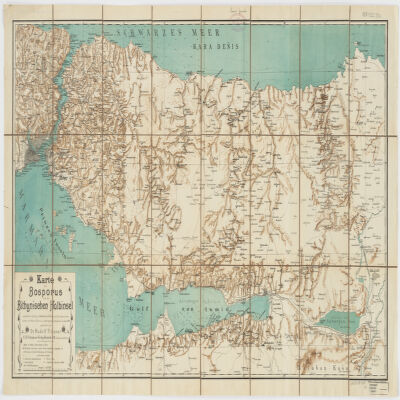
58. Karte des Bosporus und der Bithynischen Halbinsel Creator: Fitzner, Rudolph, 1864- (المنشئ) Date: Date Issued: [1900?] Language: German Geographic region: Place of Production: gw, Germany, Rostockİstanbul İli (Turkey)Kocaeli İli (Turkey)Sakarya İli (Turkey)Bosporus (Turkey) Extent: 1 map : col. ; 47 x 87 cm.
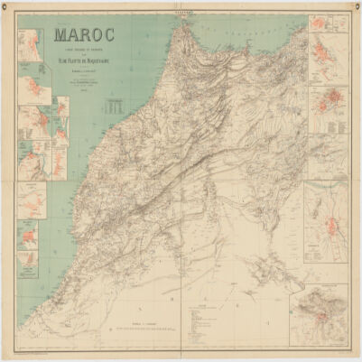
59. Maroc Creator: Flotte de Roquevaire, R. de. (المنشئ) Date: Date Issued: 1908 Language: French Geographic region: Place of Production: fr, France, ParisMoroccoAlgeriaWestern Sahara Extent: 1 map : col. ; 101 x 132 cm.
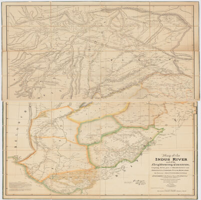
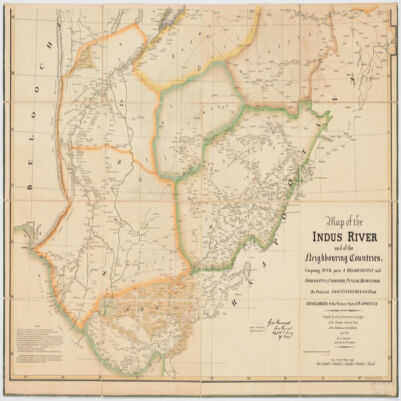
60. Map of the Indus River and the neighbouring countries, stitchedcomprising Sind, parts of Beloochistan and Afghanistan, Cashmeer, Punjab, Bhawulpoor, the protected Sikh States, Bickaneer and Jaysulmeer; & the Western Parts of Rajpootana Creator: Graham, J. (المنشئ) Date: Date Issued: Jan. 1835 Language: Indonesian Geographic region: Place of Production: ii, India, CalcuttaIndus River RegionAfghanistanPunjab (India) Extent: 1 map on 2 sheets : col. ; 147 x 104 cm, sheets 77 x 109 cm and 79 x 117 cm.
61. Map of the Indus River and the neighbouring countries, sheet 2comprising Sind, parts of Beloochistan and Afghanistan, Cashmeer, Punjab, Bhawulpoor, the protected Sikh States, Bickaneer and Jaysulmeer; & the Western Parts of Rajpootana Creator: Graham, J. (المنشئ) Date: Date Issued: Jan. 1835 Language: Indonesian Geographic region: Place of Production: ii, India, CalcuttaIndus River RegionAfghanistanPunjab (India) Extent: 1 map on 2 sheets : col. ; 147 x 104 cm, sheets 77 x 109 cm and 79 x 117 cm.
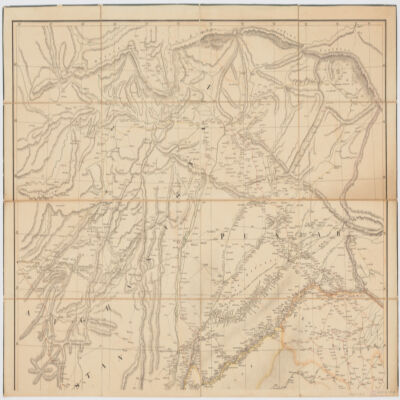
62. Map of the Indus River and the neighbouring countries, sheet 1comprising Sind, parts of Beloochistan and Afghanistan, Cashmeer, Punjab, Bhawulpoor, the protected Sikh States, Bickaneer and Jaysulmeer; & the Western Parts of Rajpootana Creator: Graham, J. (المنشئ) Date: Date Issued: Jan. 1835 Language: Indonesian Geographic region: Place of Production: ii, India, CalcuttaIndus River RegionAfghanistanPunjab (India) Extent: 1 map on 2 sheets : col. ; 147 x 104 cm, sheets 77 x 109 cm and 79 x 117 cm.
63. Plan général de la Ville du Caire Creator: Grand, Pierre Bey Date: 1874 Language: French Geographic region: Cairo; Egypt
64. The Anglo-Egyptian Sudan, Fourth edition Creator: Great Britain. War Office. General Staff. Geographical Section. Date: 1939 Language: English Geographic region: Sudan
65. "Plan d'Alexandrie ancienne : dressé d'après les travaux de Néroutsoa Bey et le Prof. E.Breccia" Creator: Hausermann, A. Date: publication date not identified Language: French Geographic region: Relief shown by contour lines, gradient tints, spot heights, and land forms.
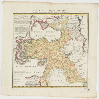
66. Turcia Asiaticaexhibens Natoliam modernam, in suos beglirbegatus divisam, itemque reliquos beglirbegatus, sive gubernationes et Prœfecturas generales, in regionibus Georgiæ, Armeniæ, Mespotamiæ, Syriæ et Arabiæ sitos, una cum Mari Nigro, Mari Azowiensi, Mari di Marmora, et Mari Ægeo, atque adiacentibus Insulis : C. P. S. C. M. = Carte de la Turquie asiatique contenant la Natolie moderne divisée en les beglerbeys & Creator: Homann Erben (Firm) (Creator) Date: Date Issued: 1771 Language: LatinFrench Geographic region: Place of Production: gw, Germany, NorimbergæMiddle EastTurkey Extent: 1 map : hand col. ; 44 x 51 cm.
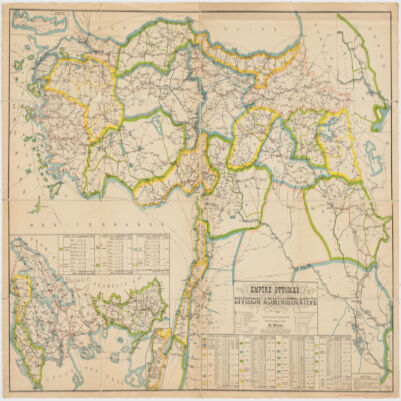
67. Empire Ottomandivision administrative Creator: Huber, R. (المنشئ) Date: Date Issued: 1899 Language: French Geographic region: Place of Production: fr, France, [S.l.]Turkey Extent: 1 map : col. ; 86 x 130 cm.
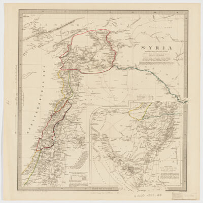
68. Syria Creator: Hughes, William, 1818-1876 (المنشئ) Date: Date Issued: Jan. 1st, 1853 Language: English Geographic region: Place of Production: uk, , LondonSyriaLebanon Extent: 1 map : col. ; 39 x 31 cm.
69. Carte de la Tunisie Creator: Institut géographique national (France) (Creator) Date: Date Issued: 1895 Language: FrenchArabicLatin Geographic region: Place of Production: fr, France, ParisTunisia Extent: 1 map on 2 sheets : col. ; 110 x 65 cm., sheet 58 x 71 cm.
70. Carte de la Tunisie Creator: Institut géographique national (France) (Creator) Date: Date Issued: 1895 Language: FrenchArabicLatin Geographic region: Place of Production: fr, France, ParisTunisia Extent: 1 map on 2 sheets : col. ; 110 x 65 cm., sheet 58 x 71 cm.
71. Carte de la Tunisie Creator: Institut géographique national (France) (Creator) Date: Date Issued: 1895 Language: FrenchArabicLatin Geographic region: Place of Production: fr, France, ParisTunisia Extent: 1 map on 2 sheets : col. ; 110 x 65 cm., sheet 58 x 71 cm.
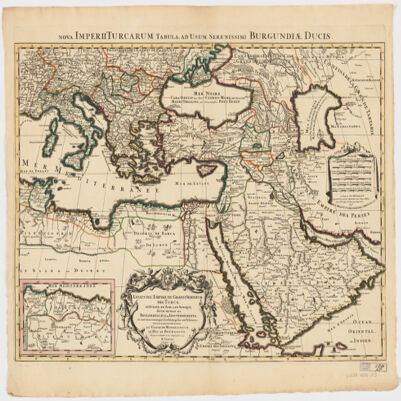
72. Estats de l'Empire du grand Seigneur des Turcs en Europe, en Asie, et en Afriquedivisé en tous ses Beglerbeglicz ou Gouvernements; où sont aussi remarqués les Estats qui luy sont Tributaires Creator: Jaillot, Alexis Hubert, 1632?-1712 (المنشئ) Date: Date Issued: 1696 Language: Latin Geographic region: Place of Production: fr, France, ParisTurkeyMiddle EastAfrica, NorthEurope, SouthernNorth AfricaSouthern Europe Time period: Ottoman Empire, 1288-1918 Extent: 1 map : hand colored ; 44 x 60 cm
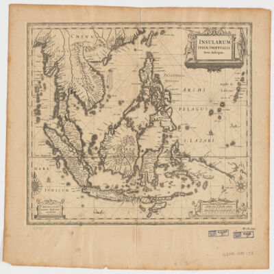
73. Insularum Indiae Orientalisnova descriptio Creator: Jansson, Jan, 1588-1664 (المنشئ) Date: Date Issued: [1650?] Language: Latin Geographic region: Place of Production: ne, Netherlands, AmstelodamiSoutheast AsiaEast Indies Extent: 1 map ; 37 x 48 cm.
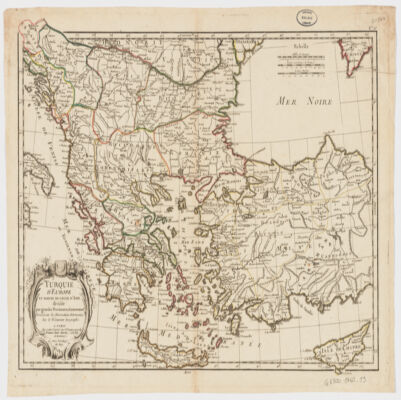
74. Turquie d'Europe et partie de celle d'Asie divisée par grandes provinces et gouvernemts Creator: Janvier, Jean Denis (المنشئ) Date: Date Issued: [1760?] Language: French Geographic region: Place of Production: fr, France, BordeauxBalkan PeninsulaTurkeyThrace, Eastern (Turkey)
75. Le Kaire. Plan particulier de la ville Creator: Jomard, M. (Edme-François), 1777-1862 Date: 1809 - 1828 Language: French Geographic region: Cairo; Egypt
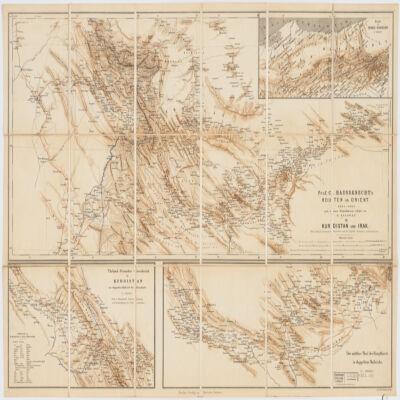
76. Prof. C. Haussknecht's Routen im Orient 1865-1869III. Kurdistan und Irak Creator: Kiepert, Heinrich, 1818-1899 (المنشئ) Date: Date Issued: 1882 Language: GermanTurkishPersian Geographic region: Place of Production: gw, Germany, BerlinKurdistanMiddle East Extent: 1 map : col. ; 32 x 71 cm.
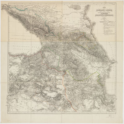
77. Karte der Kaukasus-Länder und der angränzenden Türkischen und Persischen Provinzen Armenien, Kurdistan, und Azerbeidjan Creator: Kiepert, Heinrich, 1818-1899 (المنشئ) Date: Date Issued: 1854 Language: German Geographic region: Place of Production: gw, Germany, BerlinCaucasus Extent: 1 map : hand col., dissected and mounted on linen ; 69 x 75 cm.
78. Theatrum historicum ad annum Christi quadrigentesimũin quo tũ Imperii Romani tũ Barbarorum circumincolentium status ob oculos ponitur pars orientalis Creator: L'Isle, Guillaume de, 1675-1726 (المنشئ) Date: Date Issued: [between 1759 and 1799] Language: Latin Geographic region: Place of Production: ne, Netherlands, AmstelodamiEastern Hemisphere Extent: 1 map : hand col. ; 47 x 60 cm.
79. Résumé du voyage de Yasmin entre son départ de Syrie et son installation en Allemagne Creator: Lagarde, David Contributor: "Laboratoire Interdisciplinaire Solidarités Sociétés Territoires (LISST) ; École des hautes études en sciences sociales (EHESS)-Université Toulouse - Jean Jaurès (UT2J)-École Nationale Supérieure de Formation de l'Enseignement Agricole de Toulouse-Auzeville (ENSFEA)-Centre National de la Recherche Scientifique (CNRS)" 'Institut Français du Proche-Orient (IFPO) ; MIN AFF ETRANG-Centre National de la Recherche Scientifique (CNRS)'ANR-15-CE28-0005,LAJEH,Temps des conflits / temps des migration : Réflexions sur les catégories et la généalogie des migrations au Moyen-Orient(2015) Date: 2018-03 Language: English
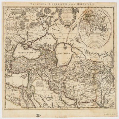
80. L'installation des réfugiés syriens dans l'Union Européenne Creator: Lagarde, David Contributor: "Laboratoire Interdisciplinaire Solidarités Sociétés Territoires (LISST) ; École des hautes études en sciences sociales (EHESS)-Université Toulouse - Jean Jaurès (UT2J)-École Nationale Supérieure de Formation de l'Enseignement Agricole de Toulouse-Auzeville (ENSFEA)-Centre National de la Recherche Scientifique (CNRS)" 'Institut Français du Proche-Orient (IFPO) ; MIN AFF ETRANG-Centre National de la Recherche Scientifique (CNRS)'ANR-15-CE28-0005,LAJEH,Temps des conflits / temps des migration : Réflexions sur les catégories et la généalogie des migrations au Moyen-Orient(2015) Date: 2018-01 Language: English
81. De la mécanique globale des flux entre Deir Mqaren et la Jordanie Creator: Lagarde, David Contributor: "Laboratoire Interdisciplinaire Solidarités Sociétés Territoires (LISST) ; École des hautes études en sciences sociales (EHESS)-Université Toulouse - Jean Jaurès (UT2J)-École Nationale Supérieure de Formation de l'Enseignement Agricole de Toulouse-Auzeville (ENSFEA)-Centre National de la Recherche Scientifique (CNRS)" 'Institut Français du Proche-Orient (IFPO) ; MIN AFF ETRANG-Centre National de la Recherche Scientifique (CNRS)'ANR-15-CE28-0005,LAJEH,Temps des conflits / temps des migration : Réflexions sur les catégories et la généalogie des migrations au Moyen-Orient(2015) Date: 2017-06 Language: English
82. Évolution du nombre de réfugiés syriens dans les pays du Moyen-Orient Creator: Lagarde, David Contributor: "Laboratoire Interdisciplinaire Solidarités Sociétés Territoires (LISST) ; École des hautes études en sciences sociales (EHESS)-Université Toulouse - Jean Jaurès (UT2J)-École Nationale Supérieure de Formation de l'Enseignement Agricole de Toulouse-Auzeville (ENSFEA)-Centre National de la Recherche Scientifique (CNRS)" 'Institut Français du Proche-Orient (IFPO) ; MIN AFF ETRANG-Centre National de la Recherche Scientifique (CNRS)'ANR-15-CE28-0005,LAJEH,Temps des conflits / temps des migration : Réflexions sur les catégories et la généalogie des migrations au Moyen-Orient(2015) Date: 2017-06 Language: English
83. Un réseau marchand transfrontalier à l'origine d'un système de mobilité Creator: Lagarde, David Contributor: "Laboratoire Interdisciplinaire Solidarités Sociétés Territoires (LISST) ; École des hautes études en sciences sociales (EHESS)-Université Toulouse - Jean Jaurès (UT2J)-École Nationale Supérieure de Formation de l'Enseignement Agricole de Toulouse-Auzeville (ENSFEA)-Centre National de la Recherche Scientifique (CNRS)" 'Institut Français du Proche-Orient (IFPO) ; MIN AFF ETRANG-Centre National de la Recherche Scientifique (CNRS)'ANR-15-CE28-0005,LAJEH,Temps des conflits / temps des migration : Réflexions sur les catégories et la généalogie des migrations au Moyen-Orient(2015) Date: 2017-08 Language: English
84. Réseaux de l'accès aux ressources de Yasmin Creator: Lagarde, David Contributor: "Laboratoire Interdisciplinaire Solidarités Sociétés Territoires (LISST) ; École des hautes études en sciences sociales (EHESS)-Université Toulouse - Jean Jaurès (UT2J)-École Nationale Supérieure de Formation de l'Enseignement Agricole de Toulouse-Auzeville (ENSFEA)-Centre National de la Recherche Scientifique (CNRS)" 'Institut Français du Proche-Orient (IFPO) ; MIN AFF ETRANG-Centre National de la Recherche Scientifique (CNRS)'ANR-15-CE28-0005,LAJEH,Temps des conflits / temps des migration : Réflexions sur les catégories et la généalogie des migrations au Moyen-Orient(2015) Date: 2017-04 Language: English
85. Début du parcours de Yasmin entre Deir Mqaren et Amman Creator: Lagarde, David Contributor: "Laboratoire Interdisciplinaire Solidarités Sociétés Territoires (LISST) ; École des hautes études en sciences sociales (EHESS)-Université Toulouse - Jean Jaurès (UT2J)-École Nationale Supérieure de Formation de l'Enseignement Agricole de Toulouse-Auzeville (ENSFEA)-Centre National de la Recherche Scientifique (CNRS)" 'Institut Français du Proche-Orient (IFPO) ; MIN AFF ETRANG-Centre National de la Recherche Scientifique (CNRS)'ANR-15-CE28-0005,LAJEH,Temps des conflits / temps des migration : Réflexions sur les catégories et la généalogie des migrations au Moyen-Orient(2015) Date: 2017-06 Language: English
86. Maps from "The Story of Cairo" Creator: Lane-Poole, Stanley, 1854-1931. Date: 1918 Language: English Geographic region: Cairo; Egypt
87. L'Etbaye [Nubie orientale] pays habité par les arabes Bicharieh ; géographie, ethnologie, mines d'or / par Linant de Bellefonds Bey [Louis-Maurice-Adolphe] Creator: Linant de Bellefonds, Louis Maurice Adolphe (1799-1883)A Date: 1868 Language: English
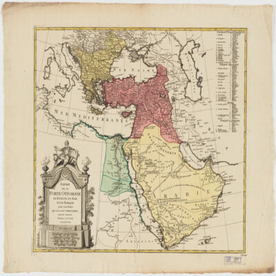
88. Empire de la Porte ottomane en Europe, en Asie et en Afrique avec les pays qui lui sont tributaires Creator: Lotter Brothers (Firm) (Creator) Date: Date Issued: [1790?] Language: French Geographic region: Place of Production: gw, Germany, AugsburgMiddle EastTurkeyEurope, SouthernAfrica, North Extent: 1 map : hand col. ; 47 x 55 cm.
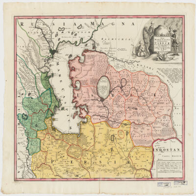
89. Nova Maris Caspii et regionis Usbeck, cum provincijs adjacentibus vera delineatio Creator: Maas, Abraham. (المنشئ) Date: Date Issued: 1735 Language: Latin Geographic region: Place of Production: gw, Germany, [Nuremberg]UzbekistanIranCaspian Sea RegionAsia, Central Extent: 1 map : hand col. ; 47 x 57 cm.
90. Egypte, Nubie et Abyssinie. Creator: Malte-Brun, Conrad, 1775-1826 Date: ca. 1850 Language: French Geographic region: Egypt; Nubia; Sudan; South Sudan; Ethiopia; Africa
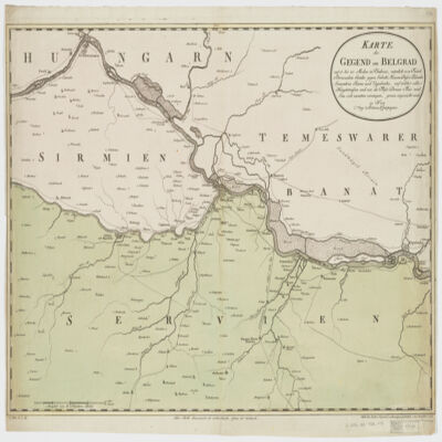
91. Karte der Gegend um Belgradauf 15 bis 20 Meilen in Umkreis, nämlich von Futak Peterwardein Semlin gegen Sabatz, Hassan Bassa Palanka Semendria Rama und Uypalanka, auf welcher alle Hauptstrassen und wie die Flüsse Donau Theis und Sau sich zusammen vereinigen, genau angezeicht sind Creator: Mansfeld. (المنشئ) Date: Date Issued: 1788 Language: German Geographic region: Place of Production: au, Austria, WienSerbiaHungary Extent: 1 map : hand col. ; 47 x 67 cm.
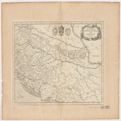
92. Sclavonia, Croatia, Bosnia cum Dalmatiæ parte Creator: Mercator, Gerhard, 1512-1594 (المنشئ) Date: Date Issued: 1630?] Language: Latin Geographic region: Place of Production: ne, Netherlands, [AmsterdamBalkan PeninsulaCroatiaBosnia and HerzegovinaSerbia Extent: 1 map ; 34 x 44 cm.
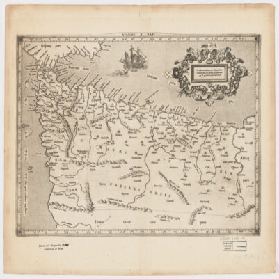
93. Africae I Tab Creator: Mercator, Gerhard, 1512-1594 (المنشئ) Date: Date Issued: 1619?] Language: Latin Geographic region: Place of Production: xx, No place, unknown, or undetermined, [S.lAfrica, North Extent: 1 map ; 31 x 45 cm.
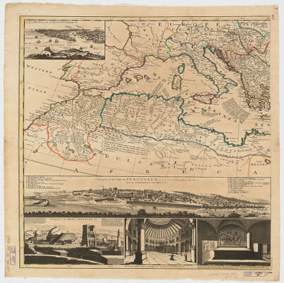
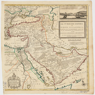
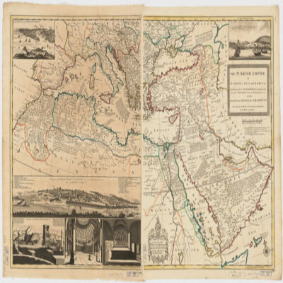
94. The Turkish Empire in Europe, Asia, and Africadividid into all its governments, together with the other territories that are tributary to it, as also the dominions of ye Emperor of Marocco [sic] according to the newest and most exact observations Creator: Moll, Herman, -1732 (المنشئ) Date: Date Issued: [1714?] Language: English Geographic region: Place of Production: enk, England, [London]TurkeyMediterranean Region Time period: Ottoman Empire, 1288-1918 Extent: 1 map on 2 sheets ; 61 x 101 cm, sheets 66 x 56 cm.
95. The Turkish Empire in Europe, Asia, and Africadividid into all its governments, together with the other territories that are tributary to it, as also the dominions of ye Emperor of Marocco [sic] according to the newest and most exact observations Creator: Moll, Herman, -1732 (المنشئ) Date: Date Issued: [1714?] Language: English Geographic region: Place of Production: enk, England, [London]TurkeyMediterranean Region Time period: Ottoman Empire, 1288-1918 Extent: 1 map on 2 sheets ; 61 x 101 cm, sheets 66 x 56 cm.
96. The Turkish Empire in Europe, Asia, and Africadividid into all its governments, together with the other territories that are tributary to it, as also the dominions of ye Emperor of Marocco [sic] according to the newest and most exact observations Creator: Moll, Herman, -1732 (المنشئ) Date: Date Issued: [1714?] Language: English Geographic region: Place of Production: enk, England, [London]TurkeyMediterranean Region Time period: Ottoman Empire, 1288-1918 Extent: 1 map on 2 sheets ; 61 x 101 cm, sheets 66 x 56 cm.